IMAGES TAKEN NEAR TO
TREGARON, SY25 6HL
Introduction
This page details the photographs taken nearby to SY25 6HL by members of the Geograph project.
The Geograph project started in 2005 with the aim of publishing, organising and preserving representative images for every square kilometre of Great Britain, Ireland and the Isle of Man.

There are currently over 7.5m images from over14,400 individuals and you can help contribute to the project by visiting https://www.geograph.org.uk
Image Map
Images are licensed for reuse under creativecommons.org/licenses/by-sa/2.0
Notes
- Clicking on the map will re-center to the selected point.
- The higher the marker number, the further away the image location is from the centre of the postcode.
Image Listing (4 Images Found)
Images are licensed for reuse under creativecommons.org/licenses/by-sa/2.0
Image
Details
Distance
1
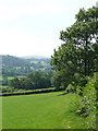
Farmland in the valley of the Afon Groes, Ceredigion
The lane to Tregaron (just over a mile away) is behind the hedge on the right. The land is almost exclusively used for grazing, with patches of deciduous woodland.
Image: © Roger D Kidd
Taken: 24 Jul 2008
0.15 miles
2
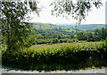
Farmland east of Tregaron, Ceredigion
Looking across the wide valley of the Afon Groes. The farm at Brynhownant is just visible in trees at the centre of the picture. On the skyline at the right of the picture is the wooded hill at Banc Tan-yr-allt SN695588.
Image: © Roger D Kidd
Taken: 24 Jul 2008
0.18 miles
3

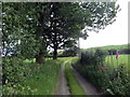
Afon Groes landscape east of Tregaron, Ceredigion
The lane to Tregaron (just over a mile away) is behind the hedge on the right.
Image: © Roger D Kidd
Taken: 24 Jul 2008
0.19 miles
4
Heol fynediad Brynhownant / Brynhownant access road
Heol fynedfa a llwybr cyhoeddus yn arwain at Ffarm Bryn Hownant.
Access road and public footpath heading towards Brynhownant Farm.
Image: © Alan Richards
Taken: 26 Jun 2019
0.25 miles