IMAGES TAKEN NEAR TO
Chapel Street, TREGARON, SY25 6HA
Introduction
This page details the photographs taken nearby to Chapel Street, SY25 6HA by members of the Geograph project.
The Geograph project started in 2005 with the aim of publishing, organising and preserving representative images for every square kilometre of Great Britain, Ireland and the Isle of Man.

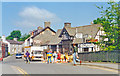
There are currently over 7.5m images from over14,400 individuals and you can help contribute to the project by visiting https://www.geograph.org.uk
Image Map
Images are licensed for reuse under creativecommons.org/licenses/by-sa/2.0
Notes
- Clicking on the map will re-center to the selected point.
- The higher the marker number, the further away the image location is from the centre of the postcode.
Image Listing (133 Images Found)
Images are licensed for reuse under creativecommons.org/licenses/by-sa/2.0
Image
Details
Distance
1
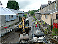
Pipelaying in the Afon Brennig, Tregaron, Ceredigion
Dredging and some reconstruction, with pipelines, is under way to reduce the risk of flooding to commercial and residential properties in the town.
Image: © Roger D Kidd
Taken: 15 Jul 2009
0.01 miles
2
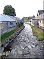
Afon Brennig, Tregaron
Looking downstream.
Image: © Maigheach-gheal
Taken: 20 Sep 2010
0.01 miles
3
Tregaron: 'downtown', 1994
View eastward from bridge over Afon Brennig up Station (long gone) Road. The scene is almost unchanged in the 15 years since (Image and others).
Image: © Ben Brooksbank
Taken: 16 Jun 1994
0.01 miles
4
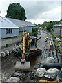
Pipelaying in the Afon Brennig, Tregaron, Ceredigion
Dredging and bank reconstruction is also taking place to reduce the risk of flooding to commercial and residential properties in the town.
Image: © Roger D Kidd
Taken: 15 Jul 2009
0.02 miles
5
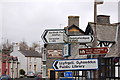
Chapel Street
Looking towards Chapel Street at its junction with Station Road.
Image: © Ian Capper
Taken: 6 Sep 2014
0.02 miles
7
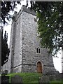
Ordnance Survey Benchmark - Tregaron, St. Caron's Church
Ordnance Survey Benchmark (OSBM) used for levelling height above Ordnance Datum (OD).
This old cut mark, which was replaced by Flush Bracket S0758 (~20m NE), has been filled in but the ends of all four lines are still visible.
Benchmark Height: 551.6 ft. OD (Liverpool)
Context: Image]
Image: © N Scott
Taken: 24 Oct 2014
0.02 miles
8
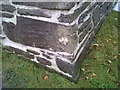
Ordnance Survey Benchmark - Tregaron, St. Caron's Church
Ordnance Survey Benchmark (OSBM) used for levelling height above Ordnance Datum (OD).
This old cut mark, which was replaced by Flush Bracket S0758 (~20m NE), has been filled in but the ends of all four lines are still visible.
Benchmark Height: 551.6 ft. OD (Liverpool)
Close-up: Image
Image: © N Scott
Taken: 24 Oct 2014
0.02 miles