IMAGES TAKEN NEAR TO
Ysbyty Ystwyth, YSTRAD MEURIG, SY25 6DB
Introduction
This page details the photographs taken nearby to SY25 6DB by members of the Geograph project.
The Geograph project started in 2005 with the aim of publishing, organising and preserving representative images for every square kilometre of Great Britain, Ireland and the Isle of Man.

There are currently over 7.5m images from over14,400 individuals and you can help contribute to the project by visiting https://www.geograph.org.uk
Image Map
Images are licensed for reuse under creativecommons.org/licenses/by-sa/2.0
Notes
- Clicking on the map will re-center to the selected point.
- The higher the marker number, the further away the image location is from the centre of the postcode.
Image Listing (4 Images Found)
Images are licensed for reuse under creativecommons.org/licenses/by-sa/2.0
Image
Details
Distance
1
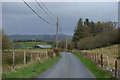
The Ystrad Meurig to Ysbyty Ystwyth road
A minor road, with few passing places north of Ystrad Meurig quarry, but carrying a fair amount of local traffic.
Image: © Nigel Brown
Taken: 9 Nov 2007
0.09 miles
4
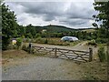
The gateway to Ystwyth Garden Centre
Family run and off-grid, according to the sign.
Image: © David Medcalf
Taken: 27 Jul 2022
0.23 miles