IMAGES TAKEN NEAR TO
Ffair Rhos, YSTRAD MEURIG, SY25 6BS
Introduction
This page details the photographs taken nearby to SY25 6BS by members of the Geograph project.
The Geograph project started in 2005 with the aim of publishing, organising and preserving representative images for every square kilometre of Great Britain, Ireland and the Isle of Man.

There are currently over 7.5m images from over14,400 individuals and you can help contribute to the project by visiting https://www.geograph.org.uk
Image Map
Images are licensed for reuse under creativecommons.org/licenses/by-sa/2.0
Notes
- Clicking on the map will re-center to the selected point.
- The higher the marker number, the further away the image location is from the centre of the postcode.
Image Listing (5 Images Found)
Images are licensed for reuse under creativecommons.org/licenses/by-sa/2.0
Image
Details
Distance
1
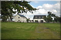
Ffair Rhos from the south east
Just part of this attractive scattered community.
Image: © Nigel Brown
Taken: 4 Apr 2014
0.12 miles
2
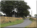
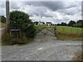
Hamlet on the track from Ffair-Rhos to Teifi Pools
This winding road has several habitations along it.
Image: © Angella Streluk
Taken: 19 Aug 2005
0.13 miles