IMAGES TAKEN NEAR TO
Cliff Road, BORTH, SY24 5NG
Introduction
This page details the photographs taken nearby to Cliff Road, SY24 5NG by members of the Geograph project.
The Geograph project started in 2005 with the aim of publishing, organising and preserving representative images for every square kilometre of Great Britain, Ireland and the Isle of Man.

There are currently over 7.5m images from over14,400 individuals and you can help contribute to the project by visiting https://www.geograph.org.uk
Image Map
Images are licensed for reuse under creativecommons.org/licenses/by-sa/2.0
Notes
- Clicking on the map will re-center to the selected point.
- The higher the marker number, the further away the image location is from the centre of the postcode.
Image Listing (152 Images Found)
Images are licensed for reuse under creativecommons.org/licenses/by-sa/2.0
Image
Details
Distance
4
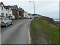
Clarach Road, Borth - a VERY cold morning.
A light dusting of snow made the walk to the paper shop quite hazardous!
Image: © Chris Denny
Taken: 20 Dec 2009
0.03 miles
5
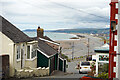
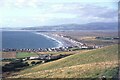
Descending towards Borth from Upper Borth
Image: © John Lucas
Taken: 5 Jul 2022
0.03 miles
7
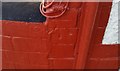
Ordnance Survey Cut Mark
This OS cut mark can be found on the south face of the house, Penlon. It marks a point 15.972m above mean sea level.
Image: © Adrian Dust
Taken: 8 Oct 2017
0.03 miles
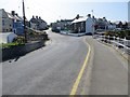
8
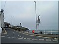
Upper Borth-Cliff Road
Looking from Clarach Road.
Image: © Ian Rob
Taken: 12 Sep 2019
0.04 miles
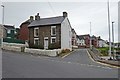
9
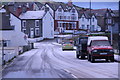
Clarach Road
Clarach road in Upper Borth, the road leading off to the right is Cliff road
Image: © Bill Nicholls
Taken: 9 Sep 2014
0.04 miles
10
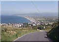
Overlooking Borth from top of steep hill
Image: © John Firth
Taken: 11 Jul 2013
0.04 miles