IMAGES TAKEN NEAR TO
Ynyslas, BORTH, SY24 5LB
Introduction
This page details the photographs taken nearby to SY24 5LB by members of the Geograph project.
The Geograph project started in 2005 with the aim of publishing, organising and preserving representative images for every square kilometre of Great Britain, Ireland and the Isle of Man.

There are currently over 7.5m images from over14,400 individuals and you can help contribute to the project by visiting https://www.geograph.org.uk
Image Map
Images are licensed for reuse under creativecommons.org/licenses/by-sa/2.0
Notes
- Clicking on the map will re-center to the selected point.
- The higher the marker number, the further away the image location is from the centre of the postcode.
Image Listing (6 Images Found)
Images are licensed for reuse under creativecommons.org/licenses/by-sa/2.0
Image
Details
Distance
1
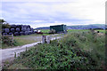
Rural clutter near Ynyslas
A typical scene from the road across the northern end of Cors Fochno with baled and bagged hay ready for winter feed.
Image: © Chris Denny
Taken: 26 Aug 2010
0.10 miles
2
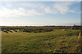
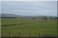
Grazing land west of Ty Mawr
West of Ty Mawr, this is only proper field of note south of the B4353, the Cors Fochno having defied other attempts to drain it. The flat nature of this great bog is clearly seen here; the slight rise in the distance is where the rock outcrop of Ynyslas rises above the bog.
Image: © Nigel Brown
Taken: 14 Dec 2008
0.11 miles
3
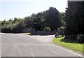
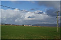
Powerlines alongside the B4353 Ty-Mawr
Image: © Steve Fareham
Taken: 15 Jul 2013
0.15 miles
5
Ynys Tachwedd Farm
This is all estuary land which has been drained for farmland.
Image: © Bill Boaden
Taken: 26 Feb 2011
0.24 miles