IMAGES TAKEN NEAR TO
TALYBONT, SY24 5DW
Introduction
This page details the photographs taken nearby to SY24 5DW by members of the Geograph project.
The Geograph project started in 2005 with the aim of publishing, organising and preserving representative images for every square kilometre of Great Britain, Ireland and the Isle of Man.

There are currently over 7.5m images from over14,400 individuals and you can help contribute to the project by visiting https://www.geograph.org.uk
Image Map
Images are licensed for reuse under creativecommons.org/licenses/by-sa/2.0
Notes
- Clicking on the map will re-center to the selected point.
- The higher the marker number, the further away the image location is from the centre of the postcode.
Image Listing (9 Images Found)
Images are licensed for reuse under creativecommons.org/licenses/by-sa/2.0
Image
Details
Distance
1
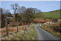
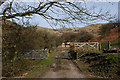
Gated road
Most gates have now been replaced by cattle grids, but not this one. The 1:25000 map shows the gate as being in this square, just (the 1:50000 shows it as being in the next square).
Image: © Nigel Brown
Taken: 16 Mar 2009
0.07 miles
2
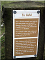
Tir Gofal (Land Care) sign near Moelgolomen
The farm track leading from Moelgolomen towards Banc Tynewydd has been designated as a 'permissive' bridleway under a Tir Gofal scheme. This provides a better route than the established right of way leading from the vicinity of Ty-newydd farm Image
Image: © John Lucas
Taken: 8 Mar 2012
0.12 miles
3
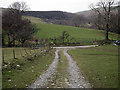
Walking down to join the road between Bont-goch and Moelgolomen
Image: © John Lucas
Taken: 8 Mar 2012
0.12 miles
4
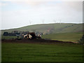
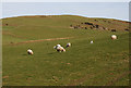
Sheep feeding on Banc Tynewydd
The Mynydd Gorddu wind-farm criminality is in view. Somewhat tongue in cheek I have added an 'Energy Infrastructure' context to this image. Did you know that the output from UK wind-farms averages some 20% of their theoretical generating capacity? And yet it is on this theoretical capacity that their construction is justified. Planning enquiries are not allowed to consider their actual capacity.
Image: © John Lucas
Taken: 8 Mar 2012
0.15 miles
6
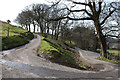
U-bend on minor road road near Moelgolomen farm
It's actually the two upper arms of a Y junction, the stem being an unsurfaced track.
Image: © Nigel Brown
Taken: 16 Mar 2009
0.18 miles
7
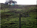
Footpath across Banc Tynewydd
The footpath climbs the hillside directly ahead. A Syfydrin cycle trail sign post points to the right.
Image: © John Lucas
Taken: 8 Mar 2012
0.19 miles
8
Track south of Moel Golomen
Marked on the map as "other route with public access". The track ends near Bwlch-glas farm, but the route continues a long way beyond there.
Image: © Nigel Brown
Taken: 16 Mar 2009
0.21 miles
9
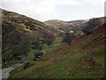
Cwm Bwlch-glas
Viewed from the slopes of Banc Tynewydd. Moel Golomen is on the left.
Image: © John Lucas
Taken: 8 Mar 2012
0.23 miles