IMAGES TAKEN NEAR TO
Nantyfallen, BOW STREET, SY24 5AY
Introduction
This page details the photographs taken nearby to Nantyfallen, SY24 5AY by members of the Geograph project.
The Geograph project started in 2005 with the aim of publishing, organising and preserving representative images for every square kilometre of Great Britain, Ireland and the Isle of Man.

There are currently over 7.5m images from over14,400 individuals and you can help contribute to the project by visiting https://www.geograph.org.uk
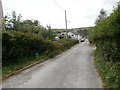
Image Map
Images are licensed for reuse under creativecommons.org/licenses/by-sa/2.0
Notes
- Clicking on the map will re-center to the selected point.
- The higher the marker number, the further away the image location is from the centre of the postcode.
Image Listing (20 Images Found)
Images are licensed for reuse under creativecommons.org/licenses/by-sa/2.0
Image
Details
Distance
1

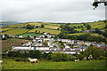
Town houses
In Afallen Park, Bow Street.
Image: © John Lucas
Taken: 23 Aug 2022
0.08 miles
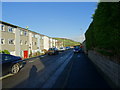
2
The Maes Afallen estate, Bow Street
Viewed from the path to Llandre.
Image: © John Lucas
Taken: 5 Jul 2022
0.08 miles
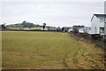
3

Maes Afallen estate, Borth
A private estate very near the centre of Bow Street. Nant Afallen is the name of a nearby stream .
Image: © John Lucas
Taken: 5 Jul 2022
0.08 miles
5

A train for Aberystwyth passing by Bow Street
Image: © John Lucas
Taken: 23 Aug 2022
0.09 miles
6

Disappearing from view
A train for Shrewsbury running past Bow Street, having just stopped at Bow Street station.
Image: © John Lucas
Taken: 5 Jul 2022
0.11 miles
8
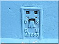
Ordnance Survey Flush Bracket G2088
This can be found on the wall of a house at Bow Street.
For more detail see : http://www.bench-marks.org.uk/bm12333
Image: © Peter Wood
Taken: 18 May 2013
0.14 miles
10

Ordnance Survey Flush Bracket (G2088)
This OS Flush Bracket can be found on the NW side of the road on a private house. It marks a point 28.675m above mean sea level.
Image: © Adrian Dust
Taken: 13 Jun 2014
0.14 miles