IMAGES TAKEN NEAR TO
Llandre, BOW STREET, SY24 5AH
Introduction
This page details the photographs taken nearby to SY24 5AH by members of the Geograph project.
The Geograph project started in 2005 with the aim of publishing, organising and preserving representative images for every square kilometre of Great Britain, Ireland and the Isle of Man.

There are currently over 7.5m images from over14,400 individuals and you can help contribute to the project by visiting https://www.geograph.org.uk
Image Map
Images are licensed for reuse under creativecommons.org/licenses/by-sa/2.0
Notes
- Clicking on the map will re-center to the selected point.
- The higher the marker number, the further away the image location is from the centre of the postcode.
Image Listing (13 Images Found)
Images are licensed for reuse under creativecommons.org/licenses/by-sa/2.0
Image
Details
Distance
1
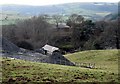
Caer Lletty-llwyd
One of several iron age hill forts in the area, the site is just visible in the very centre of the picture behind the farm buildings. There is minimal information about it and no obvious public access but some details can be found at http://www.coflein.gov.uk/en/site/303580/details/CAER+LLETTY-LLWYD
Image: © Chris Denny
Taken: 20 Feb 2011
0.04 miles
2
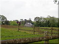
Llety Llwyd
In the woodland behind this house there is the site of a hillfort
Image: © Eirian Evans
Taken: 28 May 2021
0.06 miles
3
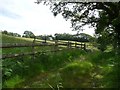
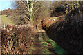
Entrance to sheep pasture, north of Llettyllwyd
Presumably an off-road space for vehicles was created because the adjacent minor road is only single track.
Image: © Christine Johnstone
Taken: 28 Jun 2015
0.16 miles
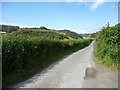
4
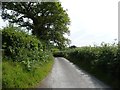
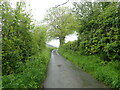
The road to Maes y Dogn
Heading south from Tal y Bont.
Image: © Christine Johnstone
Taken: 28 Jun 2015
0.16 miles
5
Minor road from Penrhyn Coch to Tal-y-Bont
Image: © Eirian Evans
Taken: 28 May 2021
0.19 miles
6
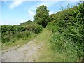
Public bridleway to Braich Garw
Heading north-east round the hillside to former quarries.
Image: © Christine Johnstone
Taken: 28 Jun 2015
0.19 miles
7
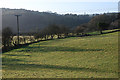
Fields east of the A487
Typical grazing land.
Image: © Nigel Brown
Taken: 22 Jan 2010
0.19 miles
8
Bridleway heading for Braich Garw
Climbing around the side of the hill.
Image: © Nigel Brown
Taken: 22 Jan 2010
0.20 miles
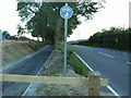
9
The road to Tal y Bont
Heading north and downhill.
Image: © Christine Johnstone
Taken: 28 Jun 2015
0.20 miles
10
Cyclepath near Talybont
Part of a new cyclepath alongside the A487 south of Talybont. Looking south. At this point it follows the line of the Hafan narrow gauge tramway, which linked quarries at Cerrig yr Hafan with the Cambrian Railways at Llandre.
Image: © Nigel Callaghan
Taken: 11 Jun 2005
0.22 miles