IMAGES TAKEN NEAR TO
Taigwynion, BOW STREET, SY24 5AG
Introduction
This page details the photographs taken nearby to Taigwynion, SY24 5AG by members of the Geograph project.
The Geograph project started in 2005 with the aim of publishing, organising and preserving representative images for every square kilometre of Great Britain, Ireland and the Isle of Man.

There are currently over 7.5m images from over14,400 individuals and you can help contribute to the project by visiting https://www.geograph.org.uk
Image Map
Images are licensed for reuse under creativecommons.org/licenses/by-sa/2.0
Notes
- Clicking on the map will re-center to the selected point.
- The higher the marker number, the further away the image location is from the centre of the postcode.
Image Listing (1 Images Found)
Images are licensed for reuse under creativecommons.org/licenses/by-sa/2.0
Image
Details
Distance
1
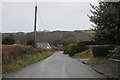
Llandre, north end
Until fairly recently this country lane linking the B4353 in Llandre with the A487 was bordered by just a few scattered dwellings. It is now quite an extended development of this up-market village.
Image: © Nigel Brown
Taken: 16 Jan 2009
0.23 miles