IMAGES TAKEN NEAR TO
Nebo, LLANON, SY23 5LH
Introduction
This page details the photographs taken nearby to SY23 5LH by members of the Geograph project.
The Geograph project started in 2005 with the aim of publishing, organising and preserving representative images for every square kilometre of Great Britain, Ireland and the Isle of Man.

There are currently over 7.5m images from over14,400 individuals and you can help contribute to the project by visiting https://www.geograph.org.uk
Image Map
Images are licensed for reuse under creativecommons.org/licenses/by-sa/2.0
Notes
- Clicking on the map will re-center to the selected point.
- The higher the marker number, the further away the image location is from the centre of the postcode.
Image Listing (3 Images Found)
Images are licensed for reuse under creativecommons.org/licenses/by-sa/2.0
Image
Details
Distance
1
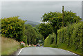
The B4337 approaching Nebo, Ceredigion
The B4337 leads between Llanwrystud and Temple Bar (near Lampeter).
Image: © Roger D Kidd
Taken: 14 Aug 2015
0.21 miles
2
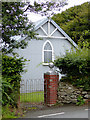
Dewi Sant Church at Nebo in Ceredigion
Built in 1913. http://www.llanon.org.uk/jimweb/dewisant.HTM
Image: © Roger D Kidd
Taken: 14 Aug 2015
0.24 miles
3
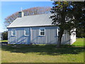
The Tin Church of St David near Nebo
Viewed from the south.
Image: © Peter Wood
Taken: 22 Apr 2015
0.24 miles