IMAGES TAKEN NEAR TO
Bronwaun, ABERYSTWYTH, SY23 4RJ
Introduction
This page details the photographs taken nearby to Bronwaun, SY23 4RJ by members of the Geograph project.
The Geograph project started in 2005 with the aim of publishing, organising and preserving representative images for every square kilometre of Great Britain, Ireland and the Isle of Man.

There are currently over 7.5m images from over14,400 individuals and you can help contribute to the project by visiting https://www.geograph.org.uk
Image Map (Loading...)


Getting Data...Please wait
Leaflet Map data © OpenStreetMap
Images are licensed for reuse under creativecommons.org/licenses/by-sa/2.0
Notes
- Clicking on the map will re-center to the selected point.
- The higher the marker number, the further away the image location is from the centre of the postcode.
Image Listing (3 Images Found)
Images are licensed for reuse under creativecommons.org/licenses/by-sa/2.0
Image
Details
Distance
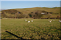
1
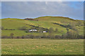
Farms on the hill
Bronwaun Ganol and Bronwaun Isaf farms seen across the flat intervening fields of the local moorland.
Image: © Nigel Brown
Taken: 26 Nov 2019
0.03 miles
2
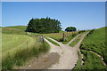
Junction of tracks near Tan-y-cwarel
The one to the right is probably the quickest way to the road.
Image: © Bill Boaden
Taken: 11 Jul 2013
0.23 miles