IMAGES TAKEN NEAR TO
Devils Bridge, ABERYSTWYTH, SY23 4QU
Introduction
This page details the photographs taken nearby to SY23 4QU by members of the Geograph project.
The Geograph project started in 2005 with the aim of publishing, organising and preserving representative images for every square kilometre of Great Britain, Ireland and the Isle of Man.

There are currently over 7.5m images from over14,400 individuals and you can help contribute to the project by visiting https://www.geograph.org.uk
Image Map
Images are licensed for reuse under creativecommons.org/licenses/by-sa/2.0
Notes
- Clicking on the map will re-center to the selected point.
- The higher the marker number, the further away the image location is from the centre of the postcode.
Image Listing (4 Images Found)
Images are licensed for reuse under creativecommons.org/licenses/by-sa/2.0
Image
Details
Distance
2
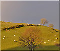
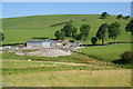
Grazing in the sun, above the Nant y Fawnog
Sheep sticking to the sunny bits while it lasts.
Image: © Nigel Brown
Taken: 3 Dec 2016
0.07 miles
4
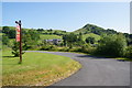
Faengrach
Holiday cottages in a fairly isolated place above the Rheidol valley.
Image: © Bill Boaden
Taken: 11 Jul 2013
0.18 miles