IMAGES TAKEN NEAR TO
Llanilar, ABERYSTWYTH, SY23 4PF
Introduction
This page details the photographs taken nearby to SY23 4PF by members of the Geograph project.
The Geograph project started in 2005 with the aim of publishing, organising and preserving representative images for every square kilometre of Great Britain, Ireland and the Isle of Man.

There are currently over 7.5m images from over14,400 individuals and you can help contribute to the project by visiting https://www.geograph.org.uk
Image Map (Loading...)


Getting Data...Please wait
Leaflet Map data © OpenStreetMap
Images are licensed for reuse under creativecommons.org/licenses/by-sa/2.0
Notes
- Clicking on the map will re-center to the selected point.
- The higher the marker number, the further away the image location is from the centre of the postcode.
Image Listing (4 Images Found)
Images are licensed for reuse under creativecommons.org/licenses/by-sa/2.0
Image
Details
Distance
1
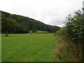
Pasture at Tyn Coed
Beside the B4575 road.
Image: © John Lucas
Taken: 2 Oct 2006
0.04 miles
3
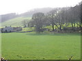
Coed Allt Fedw
Caeau a stribyn o goed gyda Fferm Tynyberllan yn y cefndir/ Fields and a line of trees with Tynyberllan Farm in the background.
Image: © Ian Medcalf
Taken: 2 Mar 2008
0.24 miles
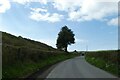
4
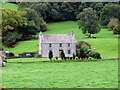
Tynberllan Farm
In the north-west corner of the square, viewed from the B4575 road.
Image: © John Lucas
Taken: 2 Oct 2006
0.25 miles