IMAGES TAKEN NEAR TO
Llanilar, ABERYSTWYTH, SY23 4PA
Introduction
This page details the photographs taken nearby to SY23 4PA by members of the Geograph project.
The Geograph project started in 2005 with the aim of publishing, organising and preserving representative images for every square kilometre of Great Britain, Ireland and the Isle of Man.

There are currently over 7.5m images from over14,400 individuals and you can help contribute to the project by visiting https://www.geograph.org.uk
Image Map
Images are licensed for reuse under creativecommons.org/licenses/by-sa/2.0
Notes
- Clicking on the map will re-center to the selected point.
- The higher the marker number, the further away the image location is from the centre of the postcode.
Image Listing (37 Images Found)
Images are licensed for reuse under creativecommons.org/licenses/by-sa/2.0
Image
Details
Distance
1
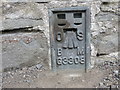
Ordnance Survey Flush Bracket G3308
This can be found on the wall of The Community Centre in Llanilar.
For more detail see : http://www.bench-marks.org.uk/bm11360
Image: © Peter Wood
Taken: 24 Apr 2015
0.02 miles
2
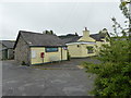
Siop y Pentref, Llanilar
The village store at Llanilar
Image: © Eirian Evans
Taken: 22 May 2015
0.02 miles
3
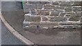
OSBM Flush Bracket G3308 - Llanilar, School Hall
Ordnance Survey Benchmark (OSBM) used for levelling height above Ordnance Datum (OD).
Height (1955): 38.5429m OD (Newlyn). Mark verified by the Ordnance Survey in 1977. Description: FL BR G3308 HALL N SIDE RD SW ANG S FACE. 0.3m above ground. 1st Order BM.
The bracket was used on the Aberystwyth to Lampeter line (G092) of the Third Geodetic Levelling of England & Wales in 1955. Description: SW angle of school Llanilar, N side of road. Abstract G 65: http://discovery.nationalarchives.gov.uk/SearchUI/details?Uri=C11264473 [OS 54/754]
Close-up: Image
Image: © N Scott
Taken: 14 Jul 2015
0.03 miles
4
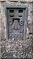
OSBM Flush Bracket G3308 - Llanilar, School Hall
Ordnance Survey Benchmark (OSBM) used for levelling height above Ordnance Datum (OD).
Height (1955): 38.5429m OD (Newlyn). Mark verified by the Ordnance Survey in 1977. Description: FL BR G3308 HALL N SIDE RD SW ANG S FACE. 0.3m above ground. 1st Order BM.
The bracket was used on the Aberystwyth to Lampeter line (G092) of the Third Geodetic Levelling of England & Wales in 1955. Description: SW angle of school Llanilar, N side of road. Abstract G 65: http://discovery.nationalarchives.gov.uk/SearchUI/details?Uri=C11264473 [OS 54/754]
Context: Image
Image: © N Scott
Taken: 14 Jul 2015
0.03 miles

8
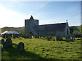
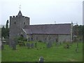
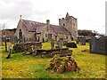
St. Hilary's church, Llanilar
Dedicated to Saint Hilary of Poitiers I believe, hence the Welsh language name of the village.
Image: © Jeremy Bolwell
Taken: 16 May 2012
0.05 miles
9
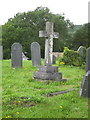
Old grave, St Hilary's Church, Llanilar
Grave of the Thomas family, formerly of Pantmawr, just outside the village of Llanilar
Image: © David Rowlands
Taken: 23 Aug 2006
0.05 miles
10
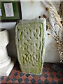
Stone at Llanilar Church
This stone with its Celtic knot design was found at Caer Maes y Mynach hill fort at Cribyn, near Lampeter. It was brought to the church in the 1950's.
Image: © Eirian Evans
Taken: 22 May 2015
0.05 miles