IMAGES TAKEN NEAR TO
Llanfihangel-y-Creuddyn, ABERYSTWYTH, SY23 4EH
Introduction
This page details the photographs taken nearby to SY23 4EH by members of the Geograph project.
The Geograph project started in 2005 with the aim of publishing, organising and preserving representative images for every square kilometre of Great Britain, Ireland and the Isle of Man.

There are currently over 7.5m images from over14,400 individuals and you can help contribute to the project by visiting https://www.geograph.org.uk
Image Map
Images are licensed for reuse under creativecommons.org/licenses/by-sa/2.0
Notes
- Clicking on the map will re-center to the selected point.
- The higher the marker number, the further away the image location is from the centre of the postcode.
Image Listing (3 Images Found)
Images are licensed for reuse under creativecommons.org/licenses/by-sa/2.0
Image
Details
Distance
2
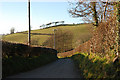
The lane to Sarnau Fawr
According to a local academic, the name Sarnau Fawr lends support to the theory that the Roman road Sarn Helen passed this way.
Image: © Nigel Brown
Taken: 26 Dec 2008
0.19 miles
3
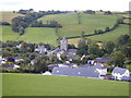
Llanfihangel y Creuddyn
Small nucleated hamlet on a tributary of the Afon Ystwyth. Fine church with solid square tower. Viewed from the north.
Image: © Bob Bowyer
Taken: 10 Sep 2005
0.24 miles