IMAGES TAKEN NEAR TO
Llanfarian, ABERYSTWYTH, SY23 4BZ
Introduction
This page details the photographs taken nearby to SY23 4BZ by members of the Geograph project.
The Geograph project started in 2005 with the aim of publishing, organising and preserving representative images for every square kilometre of Great Britain, Ireland and the Isle of Man.

There are currently over 7.5m images from over14,400 individuals and you can help contribute to the project by visiting https://www.geograph.org.uk
Image Map (Loading...)


Getting Data...Please wait
Leaflet Map data © OpenStreetMap
Images are licensed for reuse under creativecommons.org/licenses/by-sa/2.0
Notes
- Clicking on the map will re-center to the selected point.
- The higher the marker number, the further away the image location is from the centre of the postcode.
Image Listing (15 Images Found)
Images are licensed for reuse under creativecommons.org/licenses/by-sa/2.0
Image
Details
Distance
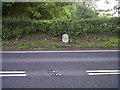
1
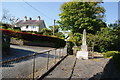
War memorial at Llanfarian
A little way out of the village to the south.
Image: © Bill Boaden
Taken: 26 May 2013
0.02 miles
2

Field and housing, Llanfarian
Housing on the northern end of Llanfarian (Pentre-bont). The Afon Ystwyth runs between the thin line of trees at the bottom of the field and the larger trees beyond.
Image: © Nigel Callaghan
Taken: 14 Jun 2005
0.07 miles
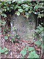
4
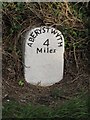
Old Milestone by the A487, Heol Antaron/Antaron Avenue, Llanfarian
Aberystwyth tombstone by the A487, in parish of Llanfarian (Ceredigion District), Llanfarian, near drive to Aber-Llolwyn.
Inscription reads:-
ABERYSTWYTH
4
Miles
Grade II listed by Cadw. Reference Number: 82505
https://cadwpublic-api.azurewebsites.net/reports/listedbuilding/FullReport?lang=&id=82505
Surveyed
Milestone Society National ID: CRD_AYCA04.
Image: © Milestone Society
Taken: Unknown
0.10 miles
5
Llanfarian, Milestone - Aberystwyth 3
The milestone used to bear an Ordnance Survey benchmark, which was used on the Warrington to Pembroke Docks line of the First Primary Levelling of England & Wales in 1851-1852. The hollow near the base of the stone was caused by its erasure. Description: 618. Mark on the 3rd milestone from Aberystwyth ; 1.65 ft. above surface. Page 533 of the abstract: http://www.trigtools.co.uk/data/1GL/1GLA_533.png
Context: Image
Image: © N Scott
Taken: 22 Jun 2015
0.10 miles
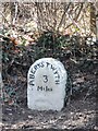
6
Llanfarian, Milestone - Aberystwyth 3
The milestone used to bear an Ordnance Survey benchmark, which was used on the Warrington to Pembroke Docks line of the First Primary Levelling of England & Wales in 1851-1852. The hollow near the base of the stone was caused by its erasure. Description: 618. Mark on the 3rd milestone from Aberystwyth; 1.65 ft. above surface. Page 533 of the abstract: http://www.trigtools.co.uk/data/1GL/1GLA_533.png
Close-up: Image
Image: © N Scott
Taken: 22 Jun 2015
0.10 miles

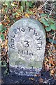
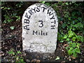
8
Old Milestone by the A487, Llanfarian
Aberystwyth tombstone by the A487, in parish of Llanfarian (Ceredigion District), North of War Memorial in Llanfarian, in bank, South side of road.
Inscription reads:-
ABERYSTWYTH
3
Miles
Grade II listed by Cadw.
Reference Number: 82505 https://cadwpublic-api.azurewebsites.net/reports/listedbuilding/FullReport?lang=&id=82505
Surveyed
Milestone Society National ID: CRD_AYCA03
Image: © Milestone Society
Taken: Unknown
0.11 miles