IMAGES TAKEN NEAR TO
Llanfarian, ABERYSTWYTH, SY23 4BX
Introduction
This page details the photographs taken nearby to SY23 4BX by members of the Geograph project.
The Geograph project started in 2005 with the aim of publishing, organising and preserving representative images for every square kilometre of Great Britain, Ireland and the Isle of Man.

There are currently over 7.5m images from over14,400 individuals and you can help contribute to the project by visiting https://www.geograph.org.uk
Image Map
Images are licensed for reuse under creativecommons.org/licenses/by-sa/2.0
Notes
- Clicking on the map will re-center to the selected point.
- The higher the marker number, the further away the image location is from the centre of the postcode.
Image Listing (33 Images Found)
Images are licensed for reuse under creativecommons.org/licenses/by-sa/2.0
Image
Details
Distance
1
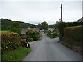
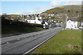
Near the crossroads in Llanfarian
The busy A487 runs across and the A485 runs off towards Tregaron ahead while this little lane runs down to meet them.
Image: © Jeremy Bolwell
Taken: 17 Aug 2011
0.05 miles
2
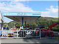
Royal Oak Garage, Llanfarian
A patriotic garage, selling mostly tractors, in Llanfarian. It is situated next to the Royal Oak public house on the A487.
Image: © Eirian Evans
Taken: 8 Oct 2010
0.06 miles
3
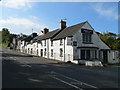
The Royal Oak, Llanfarian
Public house on the main road in Llanfarian, unfortunately gone the way of many locals, and is now closed.
Image: © Eirian Evans
Taken: 8 Oct 2010
0.06 miles
4
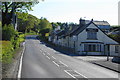
The Royal Oak, Llanfarian
Small village pub in the Ystwyth valley. The crossroads just past the pub is known as Figure Four due to the configuration of local roads, and the bus stop here carries that name. The name Figure Four appears on the 1:25,000 OS map, but what it refers to is not immediately clear on the map.
The local information was provided by Stephen Wilks, who also adds:
See this link:
http://www.ceredigion.gov.uk/utilities/action/act_download.cfm?mediaid=22572
This link is also interesting as it shows old postcards of the area from the collection of a certain Charlie Downes - almost certainly the same Charlie Downes I used to serve at a local builder's merchant in the 80s. Charlie was a real local character, and well-known all over North Ceredigion.
http://www.coflein.gov.uk/en/site/33046/collection/LLANFARIAN/?&sort_typ=dmedium&sort_ord=1&show=all
http://www.coflein.gov.uk/en/site/33046/images/LLANFARIAN/?sort_typ=imageref&sort_ord=desc
formation
Image: © Bill Boaden
Taken: 26 May 2013
0.07 miles
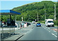
5
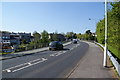
Looking north-northeast down the A487 at Llanfarian
To its junction with the A485.
Image: © John Baker
Taken: 23 Mar 2015
0.07 miles
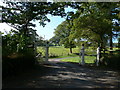
6
Handsome black and white gates
The Victorian upper classes certainly knew how to appoint their imposing properties. Entering these gates you would know straight away that you were dealing with someone special.
Image: © Jeremy Bolwell
Taken: 17 Aug 2011
0.09 miles
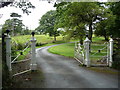
8
Gates to Cwmcoedwig Hall
North of Llanfarian.
Image: © Eirian Evans
Taken: 8 Oct 2010
0.10 miles
9
Pont Llanchaiarn
The bridge on the A487 crosses Afon Ystwyth at Llanfarian.
Image: © Bill Boaden
Taken: 26 May 2013
0.11 miles
10
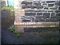
OSBM Flush Bracket S8283 - Llanfarian Church Hall
Ordnance Survey Benchmark (OSBM) used for levelling height above Ordnance Datum (OD).
Height (1955): 17.8254m OD (Newlyn). Mark verified by the Ordnance Survey in 1977. Description: FL BR S8283 NE FACE 0.9M E ANG CHURCH HALL W SIDE RD. 1st Order BM.
The bracket was used on the Aberystwyth to Lampeter (G092) and Cardigan to Aberystwyth (G082) lines of the Third Geodetic Levelling of England & Wales in 1955 and 1956 respectively. Abstract G 65: http://discovery.nationalarchives.gov.uk/SearchUI/details?Uri=C11264473 [OS 54/754]
Close-up: Image]
Image: © N Scott
Taken: 22 Jun 2015
0.12 miles