IMAGES TAKEN NEAR TO
Ger Y Llan, ABERYSTWYTH, SY23 3HQ
Introduction
This page details the photographs taken nearby to Ger Y Llan, SY23 3HQ by members of the Geograph project.
The Geograph project started in 2005 with the aim of publishing, organising and preserving representative images for every square kilometre of Great Britain, Ireland and the Isle of Man.

There are currently over 7.5m images from over14,400 individuals and you can help contribute to the project by visiting https://www.geograph.org.uk
Image Map
Images are licensed for reuse under creativecommons.org/licenses/by-sa/2.0
Notes
- Clicking on the map will re-center to the selected point.
- The higher the marker number, the further away the image location is from the centre of the postcode.
Image Listing (16 Images Found)
Images are licensed for reuse under creativecommons.org/licenses/by-sa/2.0
Image
Details
Distance
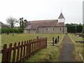
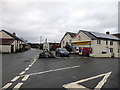
1
Penrhyncoch village centre
Dwarfed by the housing estates surrounding it.
Image: © Nigel Brown
Taken: 7 May 2009
0.08 miles
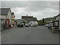
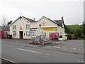
2
Village stores, Penrhyn-coch
With the war memorial to the front.
Image: © John Lucas
Taken: 1 Jan 2018
0.08 miles
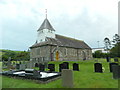
3
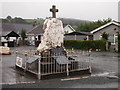
Penrhyn-Coch War Memorial
In front of the Post Office cum village shop
Image: © Eirian Evans
Taken: 28 May 2021
0.09 miles