IMAGES TAKEN NEAR TO
Penglais Road, ABERYSTWYTH, SY23 2ES
Introduction
This page details the photographs taken nearby to Penglais Road, SY23 2ES by members of the Geograph project.
The Geograph project started in 2005 with the aim of publishing, organising and preserving representative images for every square kilometre of Great Britain, Ireland and the Isle of Man.

There are currently over 7.5m images from over14,400 individuals and you can help contribute to the project by visiting https://www.geograph.org.uk
Image Map (Loading...)


Getting Data...Please wait
Leaflet Map data © OpenStreetMap
Images are licensed for reuse under creativecommons.org/licenses/by-sa/2.0
Notes
- Clicking on the map will re-center to the selected point.
- The higher the marker number, the further away the image location is from the centre of the postcode.
Image Listing (350 Images Found)
Images are licensed for reuse under creativecommons.org/licenses/by-sa/2.0
Image
Details
Distance
1
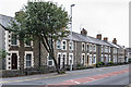
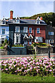
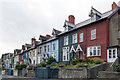
Gogerddan Cottages
Victorian terrace in Penglais Road built by Aberystwyth Town Council in the 1870s. It was an early example of social housing, involving a scheme whereby the occupiers' payment scheme enabled them to become owners of their home.
Image: © Ian Capper
Taken: 30 Aug 2013
0.03 miles
2
Elysian Grove
1930s housing off Penglais Road.
Image: © Ian Capper
Taken: 30 Aug 2013
0.03 miles
3
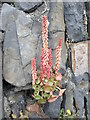
Navelwort flowering on Penglais Road
Also known as Wall Pennywort (Umbilicus rupestris), in flower. It is a perennial herb, growing on walls, in rock crevices and on stony hedge banks
Image: © Eirian Evans
Taken: 28 May 2021
0.03 miles
4
Gogerddan Cottages
Victorian terrace in Penglais Road built by Aberystwyth Town Council in the 1870s. It was an early example of social housing, involving a scheme whereby the occupiers' payment scheme enabled them to become owners of their home.
Image: © Ian Capper
Taken: 30 Aug 2013
0.03 miles
5
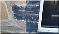
Ordnance Survey Cut Mark
This OS cut mark can be found on No1 Gogerddan Cottages. It marks a point 10.439m above mean sea level.
Image: © Adrian Dust
Taken: 8 Oct 2017
0.05 miles
6
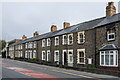
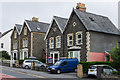
Penglais Terrace
Part of a late Victorian/Edwardian terrace on Penglais Road near its junction with Llanbadarn Road.
Image: © Ian Capper
Taken: 31 Aug 2013
0.05 miles
7
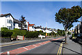
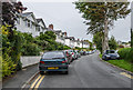
Penglais Road
1920s housing. In the far distance is the Penglais Campus of the University.
Image: © Ian Capper
Taken: 31 Aug 2013
0.05 miles
8
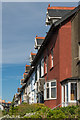
Penglais Terrace
Late Victorian/Edwardian terrace on Penglais Road.
Image: © Ian Capper
Taken: 10 Jul 2014
0.05 miles
9
Penglais Terrace
Terrace in Penglais Road dating from around the turn of the 19th/20th century.
Image: © Ian Capper
Taken: 30 Aug 2013
0.06 miles
10
Penglais Road
Late Victorian houses on Penglais Road.
Image: © Ian Capper
Taken: 30 Aug 2013
0.06 miles