IMAGES TAKEN NEAR TO
North Road, ABERYSTWYTH, SY23 2EL
Introduction
This page details the photographs taken nearby to North Road, SY23 2EL by members of the Geograph project.
The Geograph project started in 2005 with the aim of publishing, organising and preserving representative images for every square kilometre of Great Britain, Ireland and the Isle of Man.

There are currently over 7.5m images from over14,400 individuals and you can help contribute to the project by visiting https://www.geograph.org.uk
Image Map
Images are licensed for reuse under creativecommons.org/licenses/by-sa/2.0
Notes
- Clicking on the map will re-center to the selected point.
- The higher the marker number, the further away the image location is from the centre of the postcode.
Image Listing (1196 Images Found)
Images are licensed for reuse under creativecommons.org/licenses/by-sa/2.0
Image
Details
Distance
1
Looking from North Road into Vaynor Street
Image: © Basher Eyre
Taken: 26 Jun 2015
0.01 miles
2
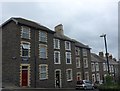
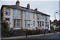
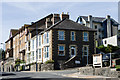
North Road
A short Victorian terrace in North Road, in the earliest section of the road to be developed.
Image: © Ian Capper
Taken: 10 Jul 2014
0.01 miles
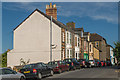
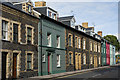
6
Vaynor Street
Victorian housing in a short road linking North Parade with North Road (in the background). Vaynor is a corruption of Y Faenor, meaning "The Manor".
Image: © Ian Capper
Taken: 8 Jul 2014
0.02 miles
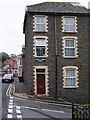
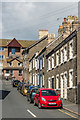
8
Northgate Terrace
Terrace on Northgate Street/Stryd y Dollborth.
Image: © Ian Capper
Taken: 31 Aug 2013
0.02 miles
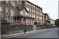
9
North Road
A late Victorian terrace among more modern housing. On the right is Infirmary Road which led to what until the development of the current Bronglais General Hospital, on the site of the former workhouse, was the local infirmary, later to become the Cardiganshire General Hospital. The modern block on the left of the photo, Llys Hen Ysgol (or Old School Court) is built on the site of what was from 1866 to 1955 the former North Road School, after which it became a further education college.
On the right is the start of a path into Penglais Local Nature Reserve.
Image: © Ian Capper
Taken: 31 Aug 2013
0.02 miles
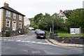
10
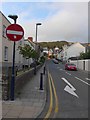
No entry sign at the bottom of Loveden Road
Image: © Basher Eyre
Taken: 26 Jun 2015
0.02 miles