IMAGES TAKEN NEAR TO
Edgehill Road, ABERYSTWYTH, SY23 1LZ
Introduction
This page details the photographs taken nearby to Edgehill Road, SY23 1LZ by members of the Geograph project.
The Geograph project started in 2005 with the aim of publishing, organising and preserving representative images for every square kilometre of Great Britain, Ireland and the Isle of Man.

There are currently over 7.5m images from over14,400 individuals and you can help contribute to the project by visiting https://www.geograph.org.uk
Image Map
Images are licensed for reuse under creativecommons.org/licenses/by-sa/2.0
Notes
- Clicking on the map will re-center to the selected point.
- The higher the marker number, the further away the image location is from the centre of the postcode.
Image Listing (1185 Images Found)
Images are licensed for reuse under creativecommons.org/licenses/by-sa/2.0
Image
Details
Distance
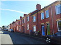
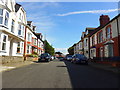
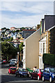
3
Edge Hill Road
Terraced housing dating from the turn of the 19th/20th centuries. Early 20th century maps name Edge Hill Road as Grefftwyr Street (meaning Craftsman's Street in English), but the current name had been given to it by the 1930s.
Image: © Ian Capper
Taken: 30 Aug 2013
0.02 miles
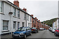
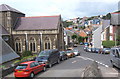
5
Trinity Road/Ffordd Drindod
Street on The Buarth, opposite Holy Trinity Church.
Image: © Ian Capper
Taken: 24 Aug 2013
0.03 miles
6
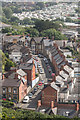
Edge Hill Road
Looking down on Edge Hill Road from the old quarry in Parc Natur Penglais. In the background are the caravans of Aberystwyth Holiday Village.
Image: © Ian Capper
Taken: 8 Jul 2016
0.03 miles

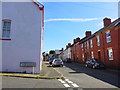
8
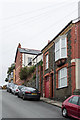
Edge Hill Road
Housing dating from the turn of the 19th/20th centuries. Early 20th century maps name Edge Hill Road as Grefftwyr Street (meaning Craftsman's Street in English), but the current name had been given to it by the 1930s.
Image: © Ian Capper
Taken: 30 Aug 2013
0.04 miles
9
View past Holy Trinity church, Aberystwyth
Image: © Andrew Hill
Taken: 15 Aug 2008
0.04 miles
10
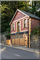
Yr Hen Weithdy
Meaning "The old Workshop", and with housing upstairs and storage for a local property maintenance firm downstairs, this building is set into the side of Buarth Mawr, on Llanbadarn Road.
Image: © Ian Capper
Taken: 28 Aug 2013
0.04 miles