IMAGES TAKEN NEAR TO
Llangawsai, ABERYSTWYTH, SY23 1HD
Introduction
This page details the photographs taken nearby to SY23 1HD by members of the Geograph project.
The Geograph project started in 2005 with the aim of publishing, organising and preserving representative images for every square kilometre of Great Britain, Ireland and the Isle of Man.

There are currently over 7.5m images from over14,400 individuals and you can help contribute to the project by visiting https://www.geograph.org.uk
Image Map
Images are licensed for reuse under creativecommons.org/licenses/by-sa/2.0
Notes
- Clicking on the map will re-center to the selected point.
- The higher the marker number, the further away the image location is from the centre of the postcode.
Image Listing (178 Images Found)
Images are licensed for reuse under creativecommons.org/licenses/by-sa/2.0
Image
Details
Distance
1
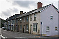
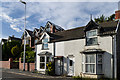
The Old Post Office
Former post office at the end of a terrace in Llangawsai, with St Georges Terrace beyond. The different wall surfaces of the corner house and the three beyond is confirmed by old maps - the corner house and St George's Terrace both appear on the 1905 map, with a gap where the three others now stand.
Image: © Ian Capper
Taken: 1 Sep 2013
0.01 miles
2
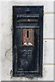
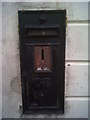
Redundant postbox
Redundant postbox on the wall of the Old Post Office in Llangawsai - see Image
Image: © Ian Capper
Taken: 1 Sep 2013
0.01 miles
3
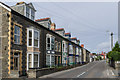
St George's Terrace
Terrace on the A44 with a date plaque of 1900.
Image: © Ian Capper
Taken: 1 Sep 2013
0.01 miles
4
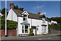
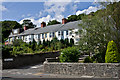
Min Y Ddol and Tegfan
Pair of semi-detached cottages on Llanbadarn Road.
Image: © Ian Capper
Taken: 31 Aug 2013
0.01 miles
5
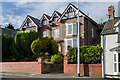
Min Y Ddol and Tegfan
Pair of semi-detached cottages on Llanbadarn Road, with Lulworth and Maeshyfryd, a semi-detached villa dating from around 1900, behind.
Image: © Ian Capper
Taken: 24 Aug 2013
0.01 miles
6
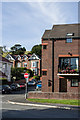
GR Postbox - Aberystwyth, Llanbadarn Road Post Office
This stopped-up Wall Box is the only evidence that this house used to be a Post Office. There used to be an Ordnance Survey cut benchmark beneath it but the rendering of the building has obliterated it.
Image: © N Scott
Taken: 6 Dec 2013
0.02 miles
7
Kings Crescent
Terrace of houses off Llanbadarn Road.
Image: © Ian Capper
Taken: 2 Aug 2013
0.02 miles
8
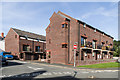
Clos Padarn
Small townhouse development off Plas Avenue. Old maps show a tannery here in the late 19th century; more recently the site was shown as a "depot".
Image: © Ian Capper
Taken: 31 Aug 2013
0.02 miles
9
Lulworth and Maeshyfryd
Semi-detached villa in Llanbadarn Road, dating from around 1900.
Image: © Ian Capper
Taken: 24 Aug 2013
0.03 miles
10
Clos Padarn
Small development off Plas Avenue. Old maps show a tannery here in the late 19th century; more recently the site was shown as a "depot". The house in the background is on Llanbadarn Road and is in two parts, Lulworth and Maeshyfryd (see Image).
Image: © Ian Capper
Taken: 31 Aug 2013
0.03 miles