IMAGES TAKEN NEAR TO
MEIFOD, SY22 6YE
Introduction
This page details the photographs taken nearby to SY22 6YE by members of the Geograph project.
The Geograph project started in 2005 with the aim of publishing, organising and preserving representative images for every square kilometre of Great Britain, Ireland and the Isle of Man.

There are currently over 7.5m images from over14,400 individuals and you can help contribute to the project by visiting https://www.geograph.org.uk
Image Map
Images are licensed for reuse under creativecommons.org/licenses/by-sa/2.0
Notes
- Clicking on the map will re-center to the selected point.
- The higher the marker number, the further away the image location is from the centre of the postcode.
Image Listing (8 Images Found)
Images are licensed for reuse under creativecommons.org/licenses/by-sa/2.0
Image
Details
Distance
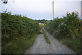
1

Lane at Bryndial cottage
Steep lane passing this cottage.
Image: © Jeremy Bolwell
Taken: 2 Feb 2014
0.02 miles
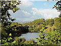
3
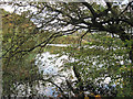
Llyn Du
The stile is at the foot of Broniarth Hill; the road down to Meifod on the far shore.
Image: © Mark Lange
Taken: 12 Jan 2008
0.15 miles

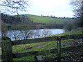
7

Gateway above Llyn Du
Winter sheep pasture.
Image: © Jeremy Bolwell
Taken: 2 Feb 2014
0.24 miles