IMAGES TAKEN NEAR TO
MEIFOD, SY22 6XX
Introduction
This page details the photographs taken nearby to SY22 6XX by members of the Geograph project.
The Geograph project started in 2005 with the aim of publishing, organising and preserving representative images for every square kilometre of Great Britain, Ireland and the Isle of Man.

There are currently over 7.5m images from over14,400 individuals and you can help contribute to the project by visiting https://www.geograph.org.uk
Image Map
Images are licensed for reuse under creativecommons.org/licenses/by-sa/2.0
Notes
- Clicking on the map will re-center to the selected point.
- The higher the marker number, the further away the image location is from the centre of the postcode.
Image Listing (3 Images Found)
Images are licensed for reuse under creativecommons.org/licenses/by-sa/2.0
Image
Details
Distance
1
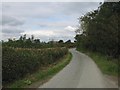
Well maintained hedge
The hedge on the left has been recently trimmed. Early autumn is a good time for this as the nesting birds have left the hedge and there is often a gap in the farm work programme.
Image: © Philip Ingram
Taken: 27 Sep 2007
0.20 miles
2
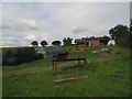
Bale stack and equipment near Collfryn
The bases will hold winter feed for stock or horses.
Image: © Philip Ingram
Taken: 27 Sep 2007
0.20 miles
3
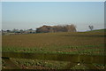
On The Horizon
Coppice close to Lower Bryn-over.
Image: © J Scott
Taken: 12 Feb 2008
0.23 miles