IMAGES TAKEN NEAR TO
LLANFECHAIN, SY22 6XF
Introduction
This page details the photographs taken nearby to SY22 6XF by members of the Geograph project.
The Geograph project started in 2005 with the aim of publishing, organising and preserving representative images for every square kilometre of Great Britain, Ireland and the Isle of Man.

There are currently over 7.5m images from over14,400 individuals and you can help contribute to the project by visiting https://www.geograph.org.uk
Image Map
Images are licensed for reuse under creativecommons.org/licenses/by-sa/2.0
Notes
- Clicking on the map will re-center to the selected point.
- The higher the marker number, the further away the image location is from the centre of the postcode.
Image Listing (5 Images Found)
Images are licensed for reuse under creativecommons.org/licenses/by-sa/2.0
Image
Details
Distance
1
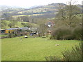
Bodynfoel farm from above
The first of the year's lambs were in the field - aaah!
Image: © Richard Law
Taken: 15 Feb 2009
0.16 miles
2
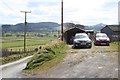
Penllys Bach entrance.
Road on the left runs towards Ty Canol.
Image: © John Firth
Taken: 23 Mar 2008
0.20 miles
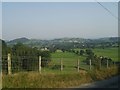
4
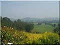
View from Penllys Bach
The Nant Llys winds out from its narrow valley towards the wide valley of the Cain near Llanfechain (in the trees to the left). The further part of this photo, beyond the first hedge, is out of square. Taken from the lane past Penllys.
Image: © Derek Harper
Taken: 14 Jul 2006
0.21 miles
5
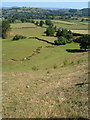
Llanfechain from Penllys-Bach
Village of Llanfechain viewed from the Road at Penllys-Bach
Image: © John Firth
Taken: 8 Aug 2003
0.22 miles