IMAGES TAKEN NEAR TO
Cae Perthi, LLANYMYNECH, SY22 6QS
Introduction
This page details the photographs taken nearby to Cae Perthi, SY22 6QS by members of the Geograph project.
The Geograph project started in 2005 with the aim of publishing, organising and preserving representative images for every square kilometre of Great Britain, Ireland and the Isle of Man.

There are currently over 7.5m images from over14,400 individuals and you can help contribute to the project by visiting https://www.geograph.org.uk
Image Map
Images are licensed for reuse under creativecommons.org/licenses/by-sa/2.0
Notes
- Clicking on the map will re-center to the selected point.
- The higher the marker number, the further away the image location is from the centre of the postcode.
Image Listing (18 Images Found)
Images are licensed for reuse under creativecommons.org/licenses/by-sa/2.0
Image
Details
Distance
1
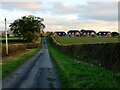
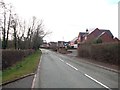
Penthryn Lane, Arddl
Looking towards a row of new-build houses.
Image: © Mike Parker
Taken: 3 Nov 2021
0.08 miles
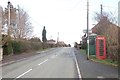
2
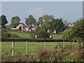
New houses at Arddlin
The village has expanded considerably in recent years.
Image: © John Haynes
Taken: 8 Oct 2007
0.10 miles
3
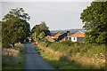
Arddlin village
Road from Burgedin to Arddlin
Image: © P Gaskell
Taken: Unknown
0.10 miles
4
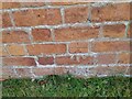
Ordnance Survey Cut Mark
This OS cut mark can be found on NW face of the chapel. It marks a point 76.083m above mean sea level.
Image: © Adrian Dust
Taken: 6 Mar 2022
0.11 miles
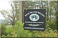
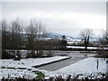
8
Wide Water Wharf .
Wide Water wharf lies at Arddleen on the Montgomery Canal
Image: © John Firth
Taken: 18 May 2008
0.12 miles
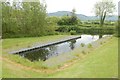
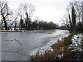
9
Frozen Wide Water wharf
This lies on the Montgomery Canal
Image: © John Firth
Taken: 15 Jan 2010
0.13 miles
10
Frozen Montgomery Canal looking South
From Arddleen
Image: © John Firth
Taken: 15 Jan 2010
0.14 miles