IMAGES TAKEN NEAR TO
Ferndale Close, LLANYMYNECH, SY22 6NA
Introduction
This page details the photographs taken nearby to Ferndale Close, SY22 6NA by members of the Geograph project.
The Geograph project started in 2005 with the aim of publishing, organising and preserving representative images for every square kilometre of Great Britain, Ireland and the Isle of Man.

There are currently over 7.5m images from over14,400 individuals and you can help contribute to the project by visiting https://www.geograph.org.uk
Image Map
Images are licensed for reuse under creativecommons.org/licenses/by-sa/2.0
Notes
- Clicking on the map will re-center to the selected point.
- The higher the marker number, the further away the image location is from the centre of the postcode.
Image Listing (12 Images Found)
Images are licensed for reuse under creativecommons.org/licenses/by-sa/2.0
Image
Details
Distance
3
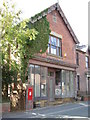
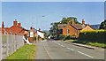
Abandoned Shop.
Shame to see an attractive building falling into disrepair.
Image: © Hefin Richards
Taken: 10 Sep 2006
0.16 miles
4
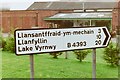
Road sign, Four Crosses, 1988
Looking at Google Street View in 2018 shows a solid hedge of conifers completely obscuring the industrial estate.
Image: © Mark Anderson
Taken: Unknown
0.17 miles
5
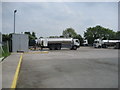
Distribution Centre, Four Crosses
The Offa's Dyke National Trail goes through this yard - operated by Lloyd Fraser (Bulk Liquids) Ltd.
Image: © Chris Heaton
Taken: 21 May 2008
0.18 miles
6
Milk tankers in the old creamery yard
The creamery has closed and been converted into flats, but the tankers remain. The two yellow lines across the yard in front of the workshop indicate the route of Llwybr Clawdd Offa (Offa's Dyke Path).
Image: © John Haynes
Taken: 8 Oct 2007
0.21 miles
7
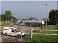
Road bridge over former railway
The old Oswestry to Welshpool line.
Image: © John H Darch
Taken: 4 Sep 2024
0.21 miles
8
Four Crosses: approaching site of former station, 1994
View eastward on the B4393 road from Llansantfraid, to the former level-crossing over the ex-Cambrian Railway main line (closed 18/1/65 Whitchurch - Oswestry (to left) - (to right) Buttington section of the route to Welshpool, Machynlleth and Aberystwyth: the station had been on the right.
Image: © Ben Brooksbank
Taken: 16 Jun 1994
0.22 miles
10
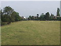
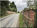
Sheep grazing Clawdd Offa (Offa's Dyke)
The slight rise can just be seen heading toward the road sign in the middle distance.
Image: © John Haynes
Taken: 8 Oct 2007
0.24 miles