IMAGES TAKEN NEAR TO
Pont Robert, MEIFOD, SY22 6JJ
Introduction
This page details the photographs taken nearby to SY22 6JJ by members of the Geograph project.
The Geograph project started in 2005 with the aim of publishing, organising and preserving representative images for every square kilometre of Great Britain, Ireland and the Isle of Man.

There are currently over 7.5m images from over14,400 individuals and you can help contribute to the project by visiting https://www.geograph.org.uk
Image Map
Images are licensed for reuse under creativecommons.org/licenses/by-sa/2.0
Notes
- Clicking on the map will re-center to the selected point.
- The higher the marker number, the further away the image location is from the centre of the postcode.
Image Listing (5 Images Found)
Images are licensed for reuse under creativecommons.org/licenses/by-sa/2.0
Image
Details
Distance
1
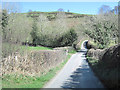
Junction near Pen-y-Coed
Looking towards Meifod
Image: © John Firth
Taken: 29 Mar 2012
0.09 miles
2
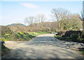
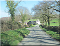
The Voel junction on the Meifod road
Near Haulfen
Image: © John Firth
Taken: 29 Mar 2012
0.09 miles
3
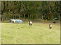
Three sheep - closer
Using the telephoto to good effect!
Image: © Jonathan Billinger
Taken: 26 Feb 2009
0.17 miles
4
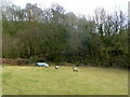
Three sheep in a small field
The lane to Pontrobert can be seen ascending steeply through the wood in the background.
Image: © Jonathan Billinger
Taken: 26 Feb 2009
0.17 miles