IMAGES TAKEN NEAR TO
High Street, MEIFOD, SY22 6DD
Introduction
This page details the photographs taken nearby to High Street, SY22 6DD by members of the Geograph project.
The Geograph project started in 2005 with the aim of publishing, organising and preserving representative images for every square kilometre of Great Britain, Ireland and the Isle of Man.

There are currently over 7.5m images from over14,400 individuals and you can help contribute to the project by visiting https://www.geograph.org.uk
Image Map
Images are licensed for reuse under creativecommons.org/licenses/by-sa/2.0
Notes
- Clicking on the map will re-center to the selected point.
- The higher the marker number, the further away the image location is from the centre of the postcode.
Image Listing (29 Images Found)
Images are licensed for reuse under creativecommons.org/licenses/by-sa/2.0
Image
Details
Distance
1
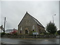
Old chapel in Meifod
Now maybe a house I think.
Image: © Jeremy Bolwell
Taken: 30 Sep 2012
0.06 miles
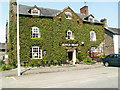
3
Property in Meifod
Distinguished looking old house in the village.
Image: © Jeremy Bolwell
Taken: 30 Sep 2012
0.08 miles
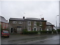
4
Canol Pentref Meifod / Meifod Village Centre
Image: © Ceri Thomas
Taken: 7 Aug 2015
0.09 miles
5
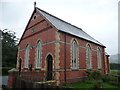
Congregational chapel in Meifod
An extremely handsome chapel dated 1891.
Image: © Jeremy Bolwell
Taken: 30 Sep 2012
0.10 miles
6
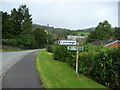
Part of Glyndwr's Way in Meifod
The fingerpost indicates the route. This is maybe one of the less scenic and inspiring sections of this waymarked long-distance footpath.
Image: © Jeremy Bolwell
Taken: 30 Sep 2012
0.11 miles
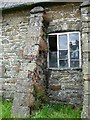
7

Old School, Meifod
Built in 1821 and one of the first National Schools in the County, the building could certainly do with some attention. It stands in the northwest corner of the nine acre churchyard surrounding the church of St Tysilio & St Mary http://www.geograph.org.uk/photo/518725
Image: © Penny Mayes
Taken: 4 Aug 2007
0.12 miles
8
Reflecting on Meifod
I think this neglected building in the north west corner of the churchyard is the original school, built in 1821 http://www.geograph.org.uk/photo/518715 . The village shop is shown in reflection.
Image: © Penny Mayes
Taken: 4 Aug 2007
0.12 miles
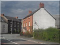
9
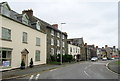
Houses in Meifod
On the main A495 running through the village.
Image: © John H Darch
Taken: 22 Jul 2019
0.14 miles
10
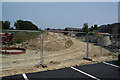
Drainage works in Meifod
Works being undertaken by Severn Trent Water. The buildings on the right are the back of the main street.
Image: © Bill Boaden
Taken: 12 Jul 2013
0.14 miles