IMAGES TAKEN NEAR TO
LLANFYLLIN, SY22 5LZ
Introduction
This page details the photographs taken nearby to SY22 5LZ by members of the Geograph project.
The Geograph project started in 2005 with the aim of publishing, organising and preserving representative images for every square kilometre of Great Britain, Ireland and the Isle of Man.

There are currently over 7.5m images from over14,400 individuals and you can help contribute to the project by visiting https://www.geograph.org.uk
Image Map
Images are licensed for reuse under creativecommons.org/licenses/by-sa/2.0
Notes
- Clicking on the map will re-center to the selected point.
- The higher the marker number, the further away the image location is from the centre of the postcode.
Image Listing (3 Images Found)
Images are licensed for reuse under creativecommons.org/licenses/by-sa/2.0
Image
Details
Distance
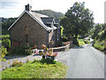
1

Tractor at Fron Haul
Farm in the Cwm-Nant-y-meichiad.
Image: © Oliver Dixon
Taken: 14 Sep 2007
0.14 miles
2
Trout View
Cottage in the Cwm-Nant-y-Meichiad. Not sure where you can see the trout!
Image: © Oliver Dixon
Taken: 14 Sep 2007
0.22 miles
3
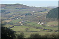
Valley Floor
A 240 metre high view point from minor road down to the plain where The Brogan flows.
Image: © J Scott
Taken: 12 Feb 2008
0.23 miles