IMAGES TAKEN NEAR TO
Bwlch-y-Cibau, LLANFYLLIN, SY22 5LP
Introduction
This page details the photographs taken nearby to SY22 5LP by members of the Geograph project.
The Geograph project started in 2005 with the aim of publishing, organising and preserving representative images for every square kilometre of Great Britain, Ireland and the Isle of Man.

There are currently over 7.5m images from over14,400 individuals and you can help contribute to the project by visiting https://www.geograph.org.uk
Image Map
Images are licensed for reuse under creativecommons.org/licenses/by-sa/2.0
Notes
- Clicking on the map will re-center to the selected point.
- The higher the marker number, the further away the image location is from the centre of the postcode.
Image Listing (7 Images Found)
Images are licensed for reuse under creativecommons.org/licenses/by-sa/2.0
Image
Details
Distance
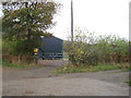
4
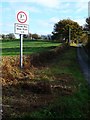
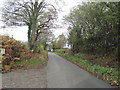
Ffordd wan
Not a road sign I've come across before. I didn't notice anything particularly weak about the road when I drove down it later.
Image: © Penny Mayes
Taken: 2 Nov 2007
0.20 miles
5
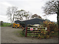
Entrance to Y Tyddyn
This lies on a right bend at the start of Bryngwyn Wood
Image: © John Firth
Taken: 6 Nov 2009
0.20 miles
6
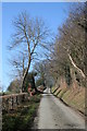
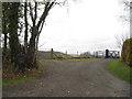
Ascending Road
Minor road adjacent track to Fferm-isaf climbs towards a wooded 251 metre summit.
Image: © J Scott
Taken: 12 Feb 2008
0.21 miles
7
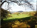
Cefnllyfnog
A peaceful valley with grazing sheep. The lower slopes of Long Hill (197m) are in the NE corner of the square.
Image: © Penny Mayes
Taken: 2 Nov 2007
0.25 miles