IMAGES TAKEN NEAR TO
Bwlch-y-Cibau, LLANFYLLIN, SY22 5LN
Introduction
This page details the photographs taken nearby to SY22 5LN by members of the Geograph project.
The Geograph project started in 2005 with the aim of publishing, organising and preserving representative images for every square kilometre of Great Britain, Ireland and the Isle of Man.

There are currently over 7.5m images from over14,400 individuals and you can help contribute to the project by visiting https://www.geograph.org.uk
Image Map
Images are licensed for reuse under creativecommons.org/licenses/by-sa/2.0
Notes
- Clicking on the map will re-center to the selected point.
- The higher the marker number, the further away the image location is from the centre of the postcode.
Image Listing (19 Images Found)
Images are licensed for reuse under creativecommons.org/licenses/by-sa/2.0
Image
Details
Distance
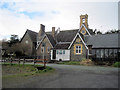
5
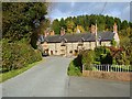
Stone terrace in Bwlch-y-cibau
Seen from Ffordd Peniarth.
Image: © Penny Mayes
Taken: 2 Nov 2007
0.04 miles
6
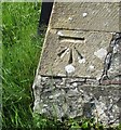
Ordnance Survey Cut Mark
This OS cut mark can be found on the south face of Christ Church. It marks a point 153.374m above mean sea level.
Image: © Adrian Dust
Taken: 12 May 2016
0.05 miles
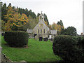
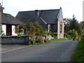
7
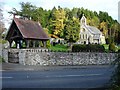
Christ Church, Bwlch-y-cibau
The deanery website has some detail on the church which includes an interior photograph http://www.mathrafal.org/parishes/cibau.htm .
Image: © Penny Mayes
Taken: 2 Nov 2007
0.05 miles
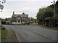
8
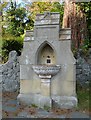
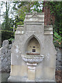
Drinking Fountain, Bwlch-y-cibau
Sited opposite the lych gate of Image
Image: © Penny Mayes
Taken: 2 Nov 2007
0.06 miles