IMAGES TAKEN NEAR TO
Maes Y Dderwen, LLANFYLLIN, SY22 5DP
Introduction
This page details the photographs taken nearby to Maes Y Dderwen, SY22 5DP by members of the Geograph project.
The Geograph project started in 2005 with the aim of publishing, organising and preserving representative images for every square kilometre of Great Britain, Ireland and the Isle of Man.

There are currently over 7.5m images from over14,400 individuals and you can help contribute to the project by visiting https://www.geograph.org.uk
Image Map
Images are licensed for reuse under creativecommons.org/licenses/by-sa/2.0
Notes
- Clicking on the map will re-center to the selected point.
- The higher the marker number, the further away the image location is from the centre of the postcode.
Image Listing (76 Images Found)
Images are licensed for reuse under creativecommons.org/licenses/by-sa/2.0
Image
Details
Distance
1
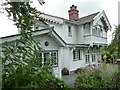
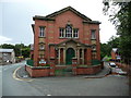
Villa Norge, Llanfyllin
A very interesting, eye-catching and memorable property on Cae Boncyn Lane. A poster on the garden gate advertises a forthcoming event, afternoon tea / te p'nawn - I'm tempted to pop round for a nose.
Image: © Jeremy Bolwell
Taken: 25 Aug 2012
0.10 miles
2
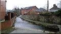
Part of Llanfyllin
The stream runs past the old chapel.
Image: © Jeremy Bolwell
Taken: 15 Mar 2015
0.12 miles
3
Tabernacl chapel in Llanfyllin
A Methodist chapel dating from 1904 I believe, having replaced earlier buildings on this site from the early 1800's.
The lane to the right or east of the chapel also carries a stream (which then runs into a culvert), so is in effect a long ford, which this family saloon car is negotiating at present.
Image: © Jeremy Bolwell
Taken: 25 Aug 2012
0.12 miles
4
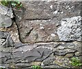
Ordnance Survey Cut Mark
This OS cut mark can be found on the NW parapet of the bridge. It marks a point 123.312m above mean sea level.
Image: © Adrian Dust
Taken: 21 Feb 2022
0.13 miles
5
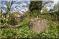
Mid Wales WWII defences: bridge at Llanfyllin - spigot mortar pedestal
-
Spigot Mortar Emplacement: DoB ID: e40364
Still guarding the bridge at Llanfyllin, the spigot mortar or "Blacker Bombard" was essentially an anti-tank weapon used almost exclusively by the Home Guard during the Second World War. They were located at strategic locations alongside other defences throughout the country in response to the German invasion threat of 1940.
Image: © Mike Searle
Taken: 8 May 2016
0.14 miles
6
Bridge Street Llanfyllin
View from the Old Bridge towards the town
Image: © Ralph
Taken: 17 Jul 2008
0.15 miles
7
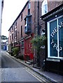
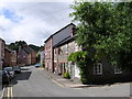
Narrow Street, Llanfyllin
An undeniably well-named street.
Image: © Penny Mayes
Taken: 6 Aug 2007
0.16 miles
8
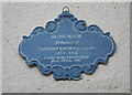
A pointless job but someone had to do it.
A plaque on Globe House.
Image: © Row17
Taken: 16 Oct 2010
0.17 miles