IMAGES TAKEN NEAR TO
Ffordd Y Cain, LLANFYLLIN, SY22 5DH
Introduction
This page details the photographs taken nearby to Ffordd Y Cain, SY22 5DH by members of the Geograph project.
The Geograph project started in 2005 with the aim of publishing, organising and preserving representative images for every square kilometre of Great Britain, Ireland and the Isle of Man.

There are currently over 7.5m images from over14,400 individuals and you can help contribute to the project by visiting https://www.geograph.org.uk
Image Map
Images are licensed for reuse under creativecommons.org/licenses/by-sa/2.0
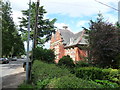
Notes
- Clicking on the map will re-center to the selected point.
- The higher the marker number, the further away the image location is from the centre of the postcode.
Image Listing (27 Images Found)
Images are licensed for reuse under creativecommons.org/licenses/by-sa/2.0
Image
Details
Distance
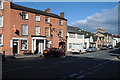
1
Llanfyllin Station
On a wet day, view SE, towards Llanymynech and Oswestry, with train from Oswestry on right. The station and branch were closed on 18/1/65.
Image: © Ben Brooksbank
Taken: 12 Apr 1960
0.09 miles
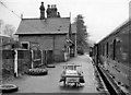
2
Running round the train, Llanfyllin 1963
Former LMS class 2 2-6-0 no.46512. The branch was built by the Cambrian Railway to tap the limestone traffic from the valley. It closed in 1965.
46512 has survived into preservation.
Image: © Alan Murray-Rust
Taken: Unknown
0.10 miles
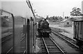
3
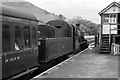
Waiting for departure, Llanfyllin 1963
Former LMS class 2 2-6-0 no.46512. The branch was built by the Cambrian Railway to tap the limestone traffic from the valley. It closed in 1965.
Image: © Alan Murray-Rust
Taken: Unknown
0.12 miles
4
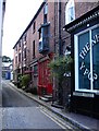
Narrow Street, Llanfyllin
An undeniably well-named street.
Image: © Penny Mayes
Taken: 6 Aug 2007
0.16 miles
5
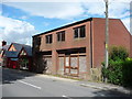
Disused retail premises in Llanfyllin
Could this be the ugliest building in the town? Even if in full and prosperous use it would smart to look at it, but in obvious dis-use I'm afraid it's a real gobsmacker of a hideous monstrosity. Especially right next to the old retail premises next door.
Image: © Jeremy Bolwell
Taken: 25 Aug 2012
0.16 miles
6
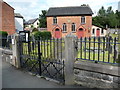
Pen Dref Welsh Independent Chapel, Llanfyllin
Pen-Dref Congregational Chapel was established originally in 1640 by the preacher Vavasour Powell and the first chapel building dated from 1707. This was subsequently destroyed by an anti-Nonconformist mob and rebuilt at the government’s expense in 1717. A second rebuilding took place in 1829 with the only element incorporated from the earlier chapel being a memorial stone, unusual for a non-conformist chapel as it includes Latin text. Remodelling works took place in the 1890's and a lean-to vestry added during the early twentieth century. The present chapel, dated 1890, is built in the Simple Round-Headed style with a long-wall entry plan. The chapel is constructed from Flemish bond red brick with a slate roof. Of particular note is the extant gallery which is supported on cast-iron piers. The renowned hymn-writer, Ann Griffiths, was converted to Non-Conformism in an outdoor ceremony at this church in 1796. Pen-Dref is now Grade 2 Listed.
Image: © Jeremy Bolwell
Taken: 25 Aug 2012
0.16 miles
7
The Old New Inn, Llanfyllin
Imaginative pub name in Llanfyllin - see also Image
Image: © Penny Mayes
Taken: 6 Aug 2007
0.17 miles
8
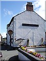
The old Llanfyllin Intermediate School
Once a small rural school, more recently a local health clinic, now mabe out of use.
Image: © Jeremy Bolwell
Taken: 25 Aug 2012
0.18 miles
9

Approaching Llanfyllin library
Library is building on the left
Image: © John Firth
Taken: 25 Feb 2015
0.19 miles