IMAGES TAKEN NEAR TO
Oakfield Drive, WELSHPOOL, SY21 9PD
Introduction
This page details the photographs taken nearby to Oakfield Drive, SY21 9PD by members of the Geograph project.
The Geograph project started in 2005 with the aim of publishing, organising and preserving representative images for every square kilometre of Great Britain, Ireland and the Isle of Man.

There are currently over 7.5m images from over14,400 individuals and you can help contribute to the project by visiting https://www.geograph.org.uk
Image Map
Images are licensed for reuse under creativecommons.org/licenses/by-sa/2.0
Notes
- Clicking on the map will re-center to the selected point.
- The higher the marker number, the further away the image location is from the centre of the postcode.
Image Listing (143 Images Found)
Images are licensed for reuse under creativecommons.org/licenses/by-sa/2.0
Image
Details
Distance
1
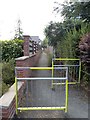
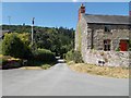
Footpath to The Oak from top of Mill Lane
Image: © John Firth
Taken: 19 Jul 2013
0.01 miles
3
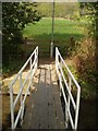
Pedestrian Bridge over Guilsfield Brook
Bridge for pedestrians over Guilsfield Brook to avoid ford
Image: © John Firth
Taken: 24 Apr 2005
0.02 miles

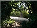
7
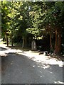
Entrance to Swn-y-nant next to The Old Mill
Image: © John Firth
Taken: 19 Jul 2013
0.03 miles
8
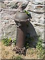
Old water pump at corner of Mill Lane and Oak Lane
Image: © John Firth
Taken: 19 Jul 2013
0.03 miles
9

Two cottages on the corner of Mill Lane
The cottages are Cil-Haul and Yewtrees
Image: © John Firth
Taken: 15 Feb 2019
0.03 miles