IMAGES TAKEN NEAR TO
Guilsfield, WELSHPOOL, SY21 9NJ
Introduction
This page details the photographs taken nearby to SY21 9NJ by members of the Geograph project.
The Geograph project started in 2005 with the aim of publishing, organising and preserving representative images for every square kilometre of Great Britain, Ireland and the Isle of Man.

There are currently over 7.5m images from over14,400 individuals and you can help contribute to the project by visiting https://www.geograph.org.uk
Image Map
Images are licensed for reuse under creativecommons.org/licenses/by-sa/2.0
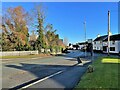
Notes
- Clicking on the map will re-center to the selected point.
- The higher the marker number, the further away the image location is from the centre of the postcode.
Image Listing (160 Images Found)
Images are licensed for reuse under creativecommons.org/licenses/by-sa/2.0
Image
Details
Distance
1
Guilsfield and St Aelhaiarn's church tower
Image: © Nigel Thompson
Taken: 10 Dec 2021
0.01 miles
2
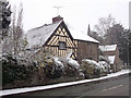
Cottage in the snow on the corner of Church Lane
Nearly opposite the Kings Head
Image: © John Firth
Taken: 18 Jan 2013
0.02 miles
3
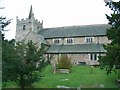
St. Aelhaiarn's Church, Guilsfield
Image: © Jennifer Luther Thomas
Taken: 28 Oct 2006
0.02 miles
5

Guilsfield from the South west
View of Guilsfield from the fields to the south west. The church can be seen right centre behind the trees
Image: © John Firth
Taken: Unknown
0.03 miles
8
The old part of the village
Park Road in the conservation area from the entrance to Oak Lane
Image: © John Firth
Taken: 26 Sep 2010
0.03 miles

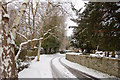
10
Towards the church from Park Road triangle
Image: © John Firth
Taken: 19 Jul 2013
0.03 miles