IMAGES TAKEN NEAR TO
Aubet Drive, WELSHPOOL, SY21 9LX
Introduction
This page details the photographs taken nearby to Aubet Drive, SY21 9LX by members of the Geograph project.
The Geograph project started in 2005 with the aim of publishing, organising and preserving representative images for every square kilometre of Great Britain, Ireland and the Isle of Man.

There are currently over 7.5m images from over14,400 individuals and you can help contribute to the project by visiting https://www.geograph.org.uk
Image Map
Images are licensed for reuse under creativecommons.org/licenses/by-sa/2.0
Notes
- Clicking on the map will re-center to the selected point.
- The higher the marker number, the further away the image location is from the centre of the postcode.
Image Listing (141 Images Found)
Images are licensed for reuse under creativecommons.org/licenses/by-sa/2.0
Image
Details
Distance
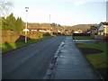
2
Aubet Drive Guilsfield
Runs parallel to Welshpool Road
Image: © John Firth
Taken: 19 Jul 2013
0.03 miles
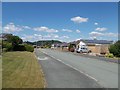
4
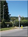
Entrance to footpath across playing fields
Also, on road, start of school restricted area
Image: © John Firth
Taken: 19 Jul 2013
0.03 miles
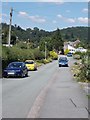
5
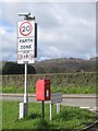
Street Furniture
Assorted street furniture at junction of Welshpool Road and Raylaw Avenue. School playing field behind hedge.
Image: © John Firth
Taken: 12 Apr 2008
0.05 miles
6

Chepstow Avenue junction with Agincourt Drive
Image: © John Firth
Taken: 11 Dec 2017
0.06 miles
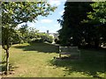
8
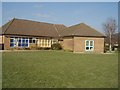
Guilsfield School
Part of Guilsfield School. Also doubles up as the Community Centre.
Image: © John Firth
Taken: Unknown
0.06 miles
10

Snowy Agincourt Drive
Viewed from Oldcastle Avenue junction
Image: © John Firth
Taken: 6 Jan 2010
0.07 miles