IMAGES TAKEN NEAR TO
Guilsfield, WELSHPOOL, SY21 9LP
Introduction
This page details the photographs taken nearby to SY21 9LP by members of the Geograph project.
The Geograph project started in 2005 with the aim of publishing, organising and preserving representative images for every square kilometre of Great Britain, Ireland and the Isle of Man.

There are currently over 7.5m images from over14,400 individuals and you can help contribute to the project by visiting https://www.geograph.org.uk
Image Map
Images are licensed for reuse under creativecommons.org/licenses/by-sa/2.0
Notes
- Clicking on the map will re-center to the selected point.
- The higher the marker number, the further away the image location is from the centre of the postcode.
Image Listing (11 Images Found)
Images are licensed for reuse under creativecommons.org/licenses/by-sa/2.0
Image
Details
Distance
2
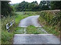
Overgrown cattle grid near Lower Varchoel
Not much good for containing determined livestock.
Image: © Penny Mayes
Taken: 29 Sep 2007
0.07 miles

5

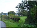
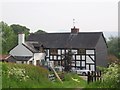
Farm buildings at Bridge
Seen across the field from Lower Varchoel.
Image: © Penny Mayes
Taken: 29 Sep 2007
0.11 miles
6

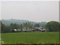
Bridge, Varchoel
The bridge crosses the defunct canal but also appears to be the name of this farm - not to be confused with Bridge Farm which is beside the next bridge in Image
Image: © Penny Mayes
Taken: 29 Sep 2007
0.14 miles
8
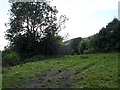
Between brook and canal
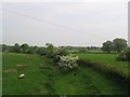
This narrow field lies between Guilsfield Brook on the left and the defunct canal behind the trees on the right.
Image: © Penny Mayes
Taken: 29 Sep 2007
0.16 miles
9

Defunct canal at Bridge
This part of the Montgomery Canal branched off just south of Arddleen and ran towards Guilsfield.
Image: © Penny Mayes
Taken: 29 Sep 2007
0.17 miles