IMAGES TAKEN NEAR TO
Pool Quay, WELSHPOOL, SY21 9LD
Introduction
This page details the photographs taken nearby to SY21 9LD by members of the Geograph project.
The Geograph project started in 2005 with the aim of publishing, organising and preserving representative images for every square kilometre of Great Britain, Ireland and the Isle of Man.

There are currently over 7.5m images from over14,400 individuals and you can help contribute to the project by visiting https://www.geograph.org.uk
Image Map
Images are licensed for reuse under creativecommons.org/licenses/by-sa/2.0
Notes
- Clicking on the map will re-center to the selected point.
- The higher the marker number, the further away the image location is from the centre of the postcode.
Image Listing (6 Images Found)
Images are licensed for reuse under creativecommons.org/licenses/by-sa/2.0
Image
Details
Distance
2
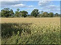
Waiting for the harvest
A field of maize near Red House.
Image: © John H Darch
Taken: 8 Oct 2022
0.15 miles
3
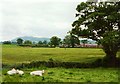
Towards the Red House
An appropriately named farm, positioned behind the floodbank of the River Severn, seen on the left.
Image: © Graham Horn
Taken: 4 Jun 2000
0.19 miles
4
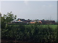
Buildings at Red House
A mix of traditional and modern buildings on this dairy farm.
Image: © John Haynes
Taken: 8 Oct 2007
0.20 miles
5
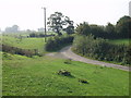
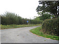
Lane at Rhyd-esgyn
Lane leading to several remote houses. The embankment on the left of the picture is the flood control bank for Afon Hafren (River Severn).
Image: © John Haynes
Taken: 8 Oct 2007
0.21 miles
