IMAGES TAKEN NEAR TO
Salop Road, WELSHPOOL, SY21 9HP
Introduction
This page details the photographs taken nearby to Salop Road, SY21 9HP by members of the Geograph project.
The Geograph project started in 2005 with the aim of publishing, organising and preserving representative images for every square kilometre of Great Britain, Ireland and the Isle of Man.

There are currently over 7.5m images from over14,400 individuals and you can help contribute to the project by visiting https://www.geograph.org.uk
Image Map
Images are licensed for reuse under creativecommons.org/licenses/by-sa/2.0
Notes
- Clicking on the map will re-center to the selected point.
- The higher the marker number, the further away the image location is from the centre of the postcode.
Image Listing (21 Images Found)
Images are licensed for reuse under creativecommons.org/licenses/by-sa/2.0
Image
Details
Distance
1
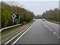
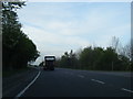
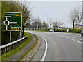
A458 Welshpool bypass
Wide, straight, flat and featureless
Image: © David Smith
Taken: 24 Apr 2015
0.03 miles
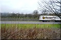
5
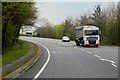
HGV on the A483 near to Buttington
Agribulk DAF XF (AY13 CSO) travelling in the direction of Welshpool.
Image: © David Dixon
Taken: 15 Apr 2016
0.08 miles
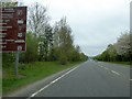
7
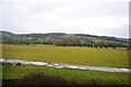
View from the train, north of Welshpool
The higher land in the distance is the Long Mountain, seen across the valley of the (unseen) River Severn / Afon Hafren. The Offa's Dyke Path runs up the gap between the two wooded areas.
Image: © Christopher Hilton
Taken: 9 Feb 2015
0.10 miles
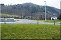
9
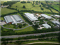
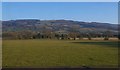
New industrial estate just outside Welshpool
This picture was taken from a Cessna 172 on a pleasure flight from Welshpool airport.
Image: © Dave Croker
Taken: 22 Jul 2008
0.13 miles