IMAGES TAKEN NEAR TO
Cyfronydd, WELSHPOOL, SY21 9HD
Introduction
This page details the photographs taken nearby to SY21 9HD by members of the Geograph project.
The Geograph project started in 2005 with the aim of publishing, organising and preserving representative images for every square kilometre of Great Britain, Ireland and the Isle of Man.

There are currently over 7.5m images from over14,400 individuals and you can help contribute to the project by visiting https://www.geograph.org.uk
Image Map
Images are licensed for reuse under creativecommons.org/licenses/by-sa/2.0
Notes
- Clicking on the map will re-center to the selected point.
- The higher the marker number, the further away the image location is from the centre of the postcode.
Image Listing (6 Images Found)
Images are licensed for reuse under creativecommons.org/licenses/by-sa/2.0
Image
Details
Distance
1
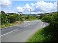
Crossroads on the B4385
Llanfair Caereinion behind the photographer, straight on for Castle Caereinion, left for Cyfronydd and right for Cefn Coch.
Image: © Penny Mayes
Taken: 12 Aug 2007
0.07 miles
2
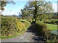
Road to Tyn-y-pwll
The bin on the right is to protect rubbish sacks from interference by wildlife while they await the roadside collection.
Image: © Penny Mayes
Taken: 28 Oct 2007
0.08 miles
4
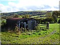
Shed by the road to Tyn-y-pwll
I don't know why this tumble-down shed rated inclusion on the 1:50000 map, it doesn't look big enough.
Image: © Penny Mayes
Taken: 28 Oct 2007
0.12 miles
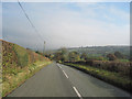
5
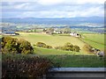
Tyn-y-pwll
Almost a kilometre from the viewpoint, only the nearer farm buildings are in this square.
Image: © Penny Mayes
Taken: 28 Oct 2007
0.20 miles
6
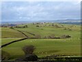
View northeast from Rhos-fawr to Rhos Fawr
It's not uncommon to find several farms with similar names in this area, but I've never noticed three together all with the same suffix, which is what the 25K map shows here. Royal Mail has one as Rhosfawr Uchaf, I think that's the one behind the photographer. I guess the postie knows who lives where.
Image: © Penny Mayes
Taken: 25 Dec 2022
0.21 miles