IMAGES TAKEN NEAR TO
Cwm Golau, Cyfronydd, WELSHPOOL, SY21 9EY
Introduction
This page details the photographs taken nearby to SY21 9EY by members of the Geograph project.
The Geograph project started in 2005 with the aim of publishing, organising and preserving representative images for every square kilometre of Great Britain, Ireland and the Isle of Man.

There are currently over 7.5m images from over14,400 individuals and you can help contribute to the project by visiting https://www.geograph.org.uk
Image Map
Images are licensed for reuse under creativecommons.org/licenses/by-sa/2.0
Notes
- Clicking on the map will re-center to the selected point.
- The higher the marker number, the further away the image location is from the centre of the postcode.
Image Listing (3 Images Found)
Images are licensed for reuse under creativecommons.org/licenses/by-sa/2.0
Image
Details
Distance
1
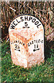
Old Milepost by the B4385, The Firs, Castle Caereinion parish
Milepost by the B4385, in parish of Castle Caereinion (Powys District), Byrwydd, opposite The Firs, East of Cil-haul, on verge.
Inscription reads:-
: LLANFAIR / 2½ / {<-arrow} : : WELSHPOOL / 5 / {arrow->} : : CASTLE-C / 1½ / {arrow->} :
Grade II listed by Cadw.
Reference Number: 18487 https://cadwpublic-api.azurewebsites.net/reports/listedbuilding/FullReport?lang=&id=18487
Surveyed
Milestone Society National ID: MOT_WPLC05
Image: © Milestone Society
Taken: Unknown
0.01 miles
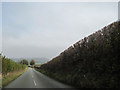
3
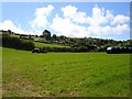
Cil-haul
One of the farms on the B4385 Castle to Llanfair road.
Image: © Penny Mayes
Taken: 12 Aug 2007
0.23 miles