IMAGES TAKEN NEAR TO
Groesllwyd, Guilsfield, WELSHPOOL, SY21 9BZ
Introduction
This page details the photographs taken nearby to SY21 9BZ by members of the Geograph project.
The Geograph project started in 2005 with the aim of publishing, organising and preserving representative images for every square kilometre of Great Britain, Ireland and the Isle of Man.

There are currently over 7.5m images from over14,400 individuals and you can help contribute to the project by visiting https://www.geograph.org.uk
Image Map
Images are licensed for reuse under creativecommons.org/licenses/by-sa/2.0
Notes
- Clicking on the map will re-center to the selected point.
- The higher the marker number, the further away the image location is from the centre of the postcode.
Image Listing (16 Images Found)
Images are licensed for reuse under creativecommons.org/licenses/by-sa/2.0
Image
Details
Distance
4
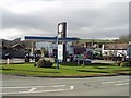
Groes Lwyd Garage
Hardings Garage and Garden Centre
Image: © John Firth
Taken: Unknown
0.07 miles
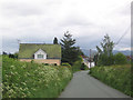
8
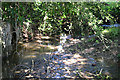
Guilsfield Brook running through Fron-y-Fele
Image: © John Firth
Taken: 9 Aug 2012
0.12 miles
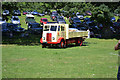
9

Tractor display at Guilsfield Show
Held at Fron-y-Fele
Image: © John Firth
Taken: 9 Aug 2012
0.12 miles
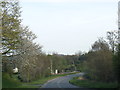
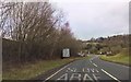
10
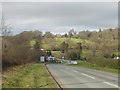
View down A490 to Groes Lwyd
Junction at bottom of hill at Hardings Garage
Image: © John Firth
Taken: Unknown
0.12 miles