IMAGES TAKEN NEAR TO
Groes-Pluen, WELSHPOOL, SY21 9BW
Introduction
This page details the photographs taken nearby to SY21 9BW by members of the Geograph project.
The Geograph project started in 2005 with the aim of publishing, organising and preserving representative images for every square kilometre of Great Britain, Ireland and the Isle of Man.

There are currently over 7.5m images from over14,400 individuals and you can help contribute to the project by visiting https://www.geograph.org.uk
Image Map
Images are licensed for reuse under creativecommons.org/licenses/by-sa/2.0
Notes
- Clicking on the map will re-center to the selected point.
- The higher the marker number, the further away the image location is from the centre of the postcode.
Image Listing (6 Images Found)
Images are licensed for reuse under creativecommons.org/licenses/by-sa/2.0
Image
Details
Distance
1
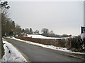
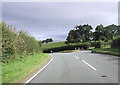
Road to Groespluan
Taken from junction with A490
Image: © John Firth
Taken: 12 Jan 2010
0.12 miles
2
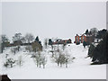
Tynllwyn farm from the A490
View of Tynllwyn Farm at Groespluan from the A490
Image: © John Firth
Taken: 9 Apr 2008
0.14 miles
3
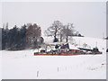
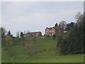
Bungalow in the snow
Viewed from A490 by Tynllwyn Farm drive
Image: © John Firth
Taken: 12 Jan 2010
0.14 miles
4
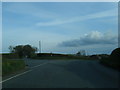
A490 at Windmill Lane junction
At Groespluan 2 roads come in from the right the other being Red Bank
Image: © John Firth
Taken: 16 Sep 2012
0.20 miles