IMAGES TAKEN NEAR TO
Heldre, Buttington, WELSHPOOL, SY21 8TE
Introduction
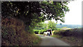
This page details the photographs taken nearby to SY21 8TE by members of the Geograph project.
The Geograph project started in 2005 with the aim of publishing, organising and preserving representative images for every square kilometre of Great Britain, Ireland and the Isle of Man.

There are currently over 7.5m images from over14,400 individuals and you can help contribute to the project by visiting https://www.geograph.org.uk
Image Map
Images are licensed for reuse under creativecommons.org/licenses/by-sa/2.0
Notes
- Clicking on the map will re-center to the selected point.
- The higher the marker number, the further away the image location is from the centre of the postcode.
Image Listing (3 Images Found)
Images are licensed for reuse under creativecommons.org/licenses/by-sa/2.0
Image
Details
Distance
3
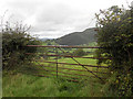
Field at Yewtree Farm, Frochas
This field had electric fences all around and contained a number of high spirited horses. A footpath is shown on the OS map running along the hedgeline, but is now fully obstructed by wooden and electric fences and massively overgrown hedges. It is as if this footpath has been closed, but still appears on the OS app.
Image: © Andrew Shannon
Taken: 8 Sep 2021
0.20 miles