IMAGES TAKEN NEAR TO
Forden, WELSHPOOL, SY21 8RY
Introduction
This page details the photographs taken nearby to SY21 8RY by members of the Geograph project.
The Geograph project started in 2005 with the aim of publishing, organising and preserving representative images for every square kilometre of Great Britain, Ireland and the Isle of Man.

There are currently over 7.5m images from over14,400 individuals and you can help contribute to the project by visiting https://www.geograph.org.uk
Image Map
Images are licensed for reuse under creativecommons.org/licenses/by-sa/2.0
Notes
- Clicking on the map will re-center to the selected point.
- The higher the marker number, the further away the image location is from the centre of the postcode.
Image Listing (16 Images Found)
Images are licensed for reuse under creativecommons.org/licenses/by-sa/2.0
Image
Details
Distance
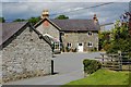
1
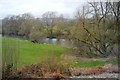
Crossing Gates, Fron Bank
Crossing Gate Cottage on the right.
Image: © Don Cawthra
Taken: 4 Oct 2007
0.09 miles
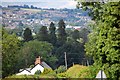
2
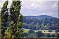
Powis Castle in the distance
A view of Powis Castle
Image: © Don Cawthra
Taken: 1 Jul 2007
0.10 miles
4
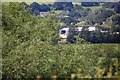
Mid Wales Airport
A view of Mid Wales Airport
Image: © Don Cawthra
Taken: 1 Jul 2007
0.11 miles
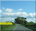
6
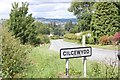
Looking to Cilcewydd from Fron Bank turning.
Image: © Don Cawthra
Taken: 1 Jul 2007
0.15 miles
7
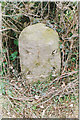
Old Milestone by the A490, south of Cilcewydd
Stone post (plate lost) by the A490, in parish of Forden with Leighton and Trelystan (Powys District), Southeast of Fron Farm, in bank, Northeast side of road.
Inscription once read:-
(Welshpool)
(3)
(Montgomery)
(4½)
Surveyed
Milestone Society National ID: MOT_WPMT03
Image: © Milestone Society
Taken: Unknown
0.16 miles