IMAGES TAKEN NEAR TO
Berriew, WELSHPOOL, SY21 8QQ
Introduction
This page details the photographs taken nearby to SY21 8QQ by members of the Geograph project.
The Geograph project started in 2005 with the aim of publishing, organising and preserving representative images for every square kilometre of Great Britain, Ireland and the Isle of Man.

There are currently over 7.5m images from over14,400 individuals and you can help contribute to the project by visiting https://www.geograph.org.uk
Image Map
Images are licensed for reuse under creativecommons.org/licenses/by-sa/2.0
Notes
- Clicking on the map will re-center to the selected point.
- The higher the marker number, the further away the image location is from the centre of the postcode.
Image Listing (4 Images Found)
Images are licensed for reuse under creativecommons.org/licenses/by-sa/2.0
Image
Details
Distance
1
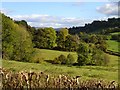
View east from Ty'n-y-coed
Various broad-leafed trees, mostly oak and ash, changing colour at their own pace. The road on the right (indicated by the straight double hedge) is in the next square.
Image: © Penny Mayes
Taken: 17 Oct 2007
0.12 miles
2
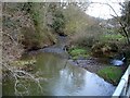
Llifior Brook
As it passes beneath the road near New House Farm.
Image: © Penny Mayes
Taken: 6 Jan 2008
0.17 miles
3
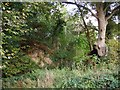
Quarry in Ty'n-y-coed Wood
There are several small disused quarries on the edge of the wood along this road. This one has left 'islands' topped by large trees.
Image: © Penny Mayes
Taken: 17 Oct 2007
0.24 miles
4
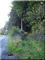
Ty'n-y-coed Wood
As coed means trees this name seems somewhat tautological. This strip of woodland lines the steep northwest side of the road for over two kilometres. The nearby farm is Ty'n-y-coed - Wood Farm.
Image: © Penny Mayes
Taken: 17 Oct 2007
0.24 miles