IMAGES TAKEN NEAR TO
Berriew, WELSHPOOL, SY21 8QF
Introduction
This page details the photographs taken nearby to SY21 8QF by members of the Geograph project.
The Geograph project started in 2005 with the aim of publishing, organising and preserving representative images for every square kilometre of Great Britain, Ireland and the Isle of Man.

There are currently over 7.5m images from over14,400 individuals and you can help contribute to the project by visiting https://www.geograph.org.uk
Image Map
Images are licensed for reuse under creativecommons.org/licenses/by-sa/2.0
Notes
- Clicking on the map will re-center to the selected point.
- The higher the marker number, the further away the image location is from the centre of the postcode.
Image Listing (2 Images Found)
Images are licensed for reuse under creativecommons.org/licenses/by-sa/2.0
Image
Details
Distance
1
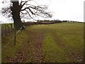
Field boundary
This hedge appears to be planted on a slight bank which makes me wonder if there was originally a wall here or if some earth has been removed for some reason.
Image: © Penny Mayes
Taken: 6 Jan 2008
0.12 miles
2
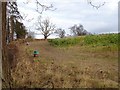
Pheasant feeders
The brassicas seem to have been planted as game cover.
Image: © Penny Mayes
Taken: 6 Jan 2008
0.17 miles