IMAGES TAKEN NEAR TO
Berriew, WELSHPOOL, SY21 8PG
Introduction
This page details the photographs taken nearby to SY21 8PG by members of the Geograph project.
The Geograph project started in 2005 with the aim of publishing, organising and preserving representative images for every square kilometre of Great Britain, Ireland and the Isle of Man.

There are currently over 7.5m images from over14,400 individuals and you can help contribute to the project by visiting https://www.geograph.org.uk
Image Map
Images are licensed for reuse under creativecommons.org/licenses/by-sa/2.0
Notes
- Clicking on the map will re-center to the selected point.
- The higher the marker number, the further away the image location is from the centre of the postcode.
Image Listing (110 Images Found)
Images are licensed for reuse under creativecommons.org/licenses/by-sa/2.0
Image
Details
Distance
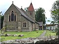
7

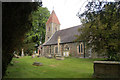
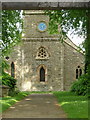
St Beuno's Church, Berriew
The church dates from 1802, though it underwent a major phase of rebuilding and restoration in 1875.
For a more detailed description see https://cpat.org.uk/Archive/churches/montgom/16709.htm
Image: © Penny Mayes
Taken: 24 Jul 2007
0.03 miles
8
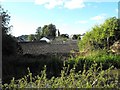
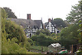
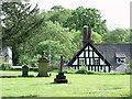
St Beuno's spire, seen from the canal
Looking across the rooftops of Maes Beuno from the tow path.
Image: © Penny Mayes
Taken: 9 Sep 2009
0.03 miles
10
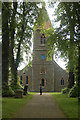
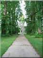
St. Beuno's Church
Church of St. Beuno, Berriew.
Image: © Alan Hughes
Taken: 27 Aug 2016
0.04 miles